Filters
Date Range
Contacts
Tag Types
Tag Schemes
|

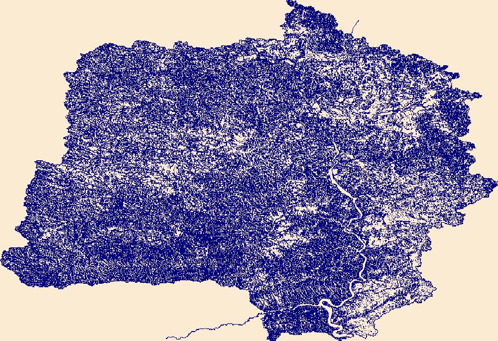
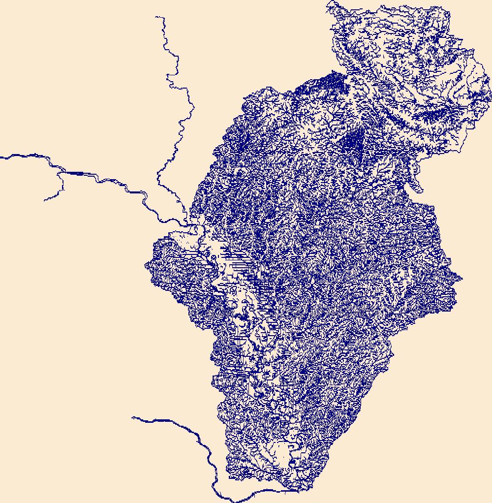
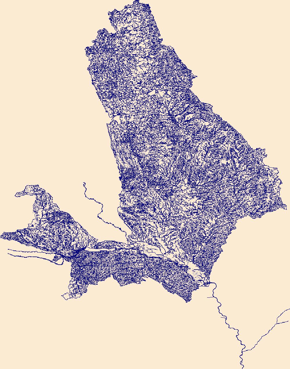
The High Resolution National Hydrography Dataset Plus (NHDPlus HR) is an integrated set of geospatial data layers, including the best available National Hydrography Dataset (NHD), the 10-meter 3D Elevation Program Digital Elevation Model (3DEP DEM), and the National Watershed Boundary Dataset (WBD). The NHDPlus HR combines the NHD, 3DEP DEMs, and WBD to create a stream network with linear referencing, feature naming, "value added attributes" (VAAs), elevation-derived catchments, and other features for hydrologic data analysis. The stream network with linear referencing is a system of data relationships applied to hydrographic systems so that one stream reach "flows" into another and "events" can be tied to and traced...
Tags: AuroraCounty,
BeadleCounty,
BennettCounty,
BoydCounty,
BruleCounty, All tags...
BuffaloCounty,
Charles MixCounty,
CherryCounty,
DawesCounty,
DouglasCounty,
Downloadable Data,
Fall RiverCounty,
FaulkCounty,
FileGDB,
FileGDB 10.1,
GregoryCounty,
HU-4 Subregion,
HU-4 Subregion,
HaakonCounty,
HandCounty,
HughesCounty,
HydeCounty,
Hydrography,
JacksonCounty,
JerauldCounty,
JonesCounty,
LymanCounty,
MelletteCounty,
NHDPlus HR Rasters,
NHDPlus High Resolution (NHDPlus HR),
National Hydrography Dataset (NHD),
National Hydrography Dataset Plus High Resolution (NHDPlus HR),
National Hydrography Dataset Plus High Resolution (NHDPlus HR) Current,
Oglala LakotaCounty,
PenningtonCounty,
PotterCounty,
SD,
SheridanCounty,
SiouxCounty,
South Dakota,
StanleyCounty,
SullyCounty,
ToddCounty,
TrippCounty,
US,
United States,
base maps,
cartography,
catchments,
channels,
digital elevation models,
drainage basins,
earth sciences,
elevation,
environment,
geographic information systems,
geoscientific,
geospatial analysis,
hydrographic datasets,
hydrographic features,
hydrology,
imagery,
inland waters,
lakes,
land surface characteristics,
reservoirs,
river reaches,
rivers,
streamflow,
streamflow data,
streams,
topography,
water bodies,
water quality,
water resources,
watersheds, Fewer tags
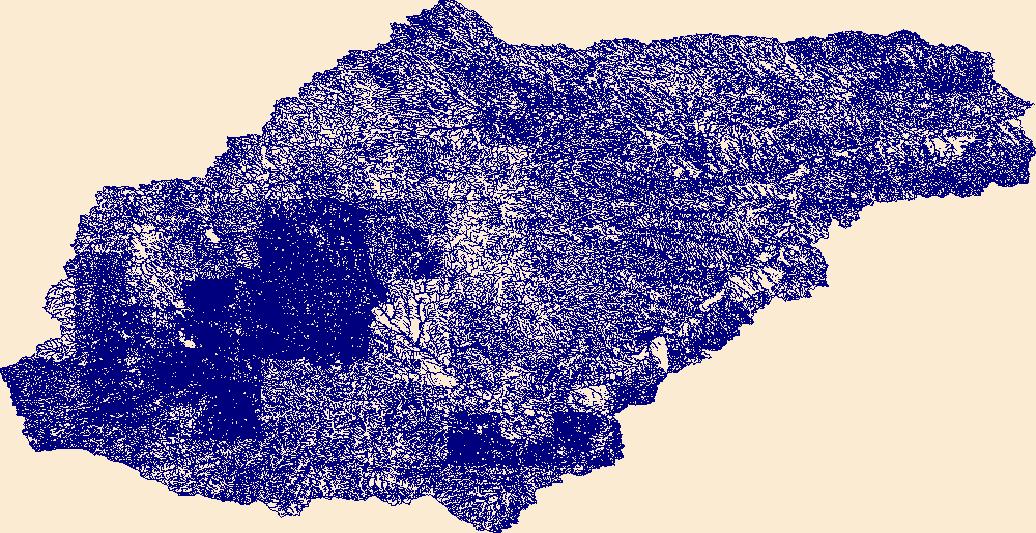
The High Resolution National Hydrography Dataset Plus (NHDPlus HR) is an integrated set of geospatial data layers, including the best available National Hydrography Dataset (NHD), the 10-meter 3D Elevation Program Digital Elevation Model (3DEP DEM), and the National Watershed Boundary Dataset (WBD). The NHDPlus HR combines the NHD, 3DEP DEMs, and WBD to create a stream network with linear referencing, feature naming, "value added attributes" (VAAs), elevation-derived catchments, and other features for hydrologic data analysis. The stream network with linear referencing is a system of data relationships applied to hydrographic systems so that one stream reach "flows" into another and "events" can be tied to and traced...
Tags: AdamsCounty,
BillingsCounty,
BowmanCounty,
BurleighCounty,
ButteCounty, All tags...
CampbellCounty,
CorsonCounty,
DeweyCounty,
DickeyCounty,
Downloadable Data,
DunnCounty,
EdmundsCounty,
EmmonsCounty,
FaulkCounty,
FileGDB,
FileGDB 10.1,
GrantCounty,
HU-4 Subregion,
HU-4 Subregion,
HaakonCounty,
HardingCounty,
HettingerCounty,
HughesCounty,
HydeCounty,
Hydrography,
KidderCounty,
LoganCounty,
McHenryCounty,
McIntoshCounty,
McKenzieCounty,
McLeanCounty,
McPhersonCounty,
MeadeCounty,
MercerCounty,
MortonCounty,
ND,
NHDPlus HR Rasters,
NHDPlus High Resolution (NHDPlus HR),
National Hydrography Dataset (NHD),
National Hydrography Dataset Plus High Resolution (NHDPlus HR),
National Hydrography Dataset Plus High Resolution (NHDPlus HR) Current,
North Dakota,
OliverCounty,
PerkinsCounty,
PotterCounty,
SheridanCounty,
SiouxCounty,
SlopeCounty,
StanleyCounty,
StarkCounty,
StutsmanCounty,
SullyCounty,
US,
United States,
WalworthCounty,
WardCounty,
WellsCounty,
ZiebachCounty,
base maps,
cartography,
catchments,
channels,
digital elevation models,
drainage basins,
earth sciences,
elevation,
environment,
geographic information systems,
geoscientific,
geospatial analysis,
hydrographic datasets,
hydrographic features,
hydrology,
imagery,
inland waters,
lakes,
land surface characteristics,
reservoirs,
river reaches,
rivers,
streamflow,
streamflow data,
streams,
topography,
water bodies,
water quality,
water resources,
watersheds, Fewer tags
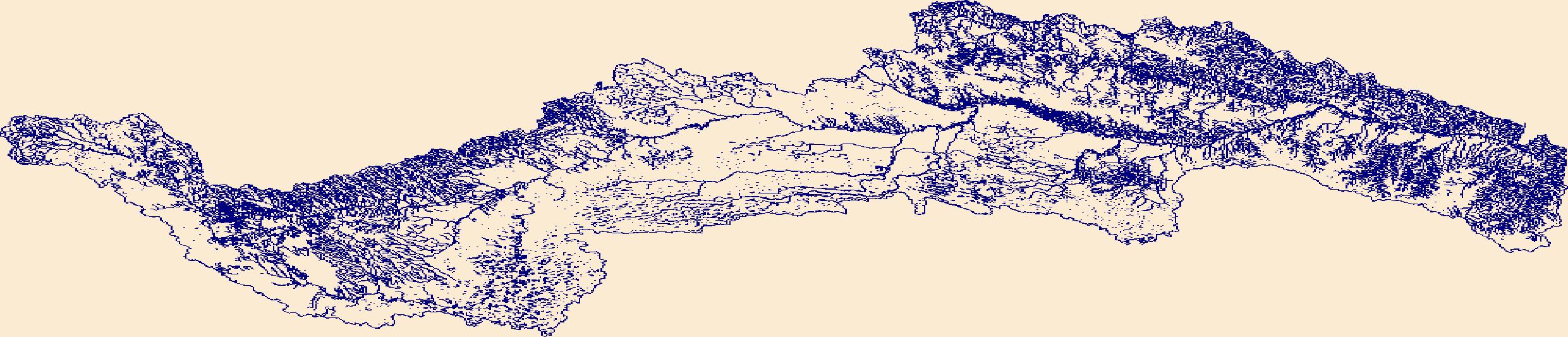
The High Resolution National Hydrography Dataset Plus (NHDPlus HR) is an integrated set of geospatial data layers, including the best available National Hydrography Dataset (NHD), the 10-meter 3D Elevation Program Digital Elevation Model (3DEP DEM), and the National Watershed Boundary Dataset (WBD). The NHDPlus HR combines the NHD, 3DEP DEMs, and WBD to create a stream network with linear referencing, feature naming, "value added attributes" (VAAs), elevation-derived catchments, and other features for hydrologic data analysis. The stream network with linear referencing is a system of data relationships applied to hydrographic systems so that one stream reach "flows" into another and "events" can be tied to and traced...
Tags: ButteCounty,
CampbellCounty,
CarterCounty,
ConverseCounty,
CrookCounty, All tags...
CusterCounty,
DawesCounty,
Downloadable Data,
Fall RiverCounty,
FileGDB,
FileGDB 10.1,
HU-4 Subregion,
HU-4 Subregion,
HaakonCounty,
Hydrography,
LawrenceCounty,
MeadeCounty,
NHDPlus HR Rasters,
NHDPlus High Resolution (NHDPlus HR),
National Hydrography Dataset (NHD),
National Hydrography Dataset Plus High Resolution (NHDPlus HR),
National Hydrography Dataset Plus High Resolution (NHDPlus HR) Current,
NatronaCounty,
NiobraraCounty,
Oglala LakotaCounty,
PenningtonCounty,
SiouxCounty,
US,
United States,
WY,
WestonCounty,
Wyoming,
ZiebachCounty,
base maps,
cartography,
catchments,
channels,
digital elevation models,
drainage basins,
earth sciences,
elevation,
environment,
geographic information systems,
geoscientific,
geospatial analysis,
hydrographic datasets,
hydrographic features,
hydrology,
imagery,
inland waters,
lakes,
land surface characteristics,
reservoirs,
river reaches,
rivers,
streamflow,
streamflow data,
streams,
topography,
water bodies,
water quality,
water resources,
watersheds, Fewer tags
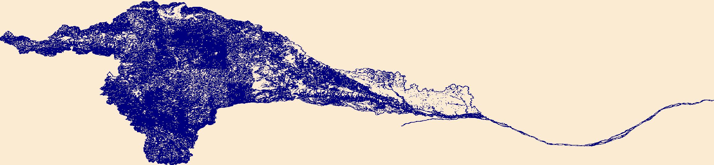
The High Resolution National Hydrography Dataset Plus (NHDPlus HR) is an integrated set of geospatial data layers, including the best available National Hydrography Dataset (NHD), the 10-meter 3D Elevation Program Digital Elevation Model (3DEP DEM), and the National Watershed Boundary Dataset (WBD). The NHDPlus HR combines the NHD, 3DEP DEMs, and WBD to create a stream network with linear referencing, feature naming, "value added attributes" (VAAs), elevation-derived catchments, and other features for hydrologic data analysis. The stream network with linear referencing is a system of data relationships applied to hydrographic systems so that one stream reach "flows" into another and "events" can be tied to and traced...
Tags: AntelopeCounty,
BennettCounty,
Box ButteCounty,
BoydCounty,
BrownCounty, All tags...
CherryCounty,
DawesCounty,
Downloadable Data,
FileGDB,
FileGDB 10.1,
GardenCounty,
GoshenCounty,
GregoryCounty,
HU-4 Subregion,
HU-4 Subregion,
HoltCounty,
Hydrography,
Keya PahaCounty,
KnoxCounty,
MorrillCounty,
NHDPlus HR Rasters,
NHDPlus High Resolution (NHDPlus HR),
National Hydrography Dataset (NHD),
National Hydrography Dataset Plus High Resolution (NHDPlus HR),
National Hydrography Dataset Plus High Resolution (NHDPlus HR) Current,
NiobraraCounty,
Oglala LakotaCounty,
RockCounty,
SD,
Scotts BluffCounty,
SheridanCounty,
SiouxCounty,
South Dakota,
ToddCounty,
TrippCounty,
US,
United States,
base maps,
cartography,
catchments,
channels,
digital elevation models,
drainage basins,
earth sciences,
elevation,
environment,
geographic information systems,
geoscientific,
geospatial analysis,
hydrographic datasets,
hydrographic features,
hydrology,
imagery,
inland waters,
lakes,
land surface characteristics,
reservoirs,
river reaches,
rivers,
streamflow,
streamflow data,
streams,
topography,
water bodies,
water quality,
water resources,
watersheds, Fewer tags
The High Resolution National Hydrography Dataset Plus (NHDPlus HR) is an integrated set of geospatial data layers, including the best available National Hydrography Dataset (NHD), the 10-meter 3D Elevation Program Digital Elevation Model (3DEP DEM), and the National Watershed Boundary Dataset (WBD). The NHDPlus HR combines the NHD, 3DEP DEMs, and WBD to create a stream network with linear referencing, feature naming, "value added attributes" (VAAs), elevation-derived catchments, and other features for hydrologic data analysis. The stream network with linear referencing is a system of data relationships applied to hydrographic systems so that one stream reach "flows" into another and "events" can be tied to and traced...
Tags: AlbanyCounty,
ArthurCounty,
BannerCounty,
Box ButteCounty,
CarbonCounty, All tags...
CheyenneCounty,
ConverseCounty,
DeuelCounty,
Downloadable Data,
FileGDB,
FileGDB 10.1,
FremontCounty,
GardenCounty,
GoshenCounty,
GrandCounty,
HU-4 Subregion,
HU-4 Subregion,
Hydrography,
JacksonCounty,
KeithCounty,
KimballCounty,
LaramieCounty,
LarimerCounty,
LincolnCounty,
McPhersonCounty,
MorrillCounty,
NE,
NHDPlus HR Rasters,
NHDPlus High Resolution (NHDPlus HR),
National Hydrography Dataset (NHD),
National Hydrography Dataset Plus High Resolution (NHDPlus HR),
National Hydrography Dataset Plus High Resolution (NHDPlus HR) Current,
NatronaCounty,
Nebraska,
NiobraraCounty,
PlatteCounty,
RouttCounty,
Scotts BluffCounty,
SiouxCounty,
SubletteCounty,
SweetwaterCounty,
US,
United States,
base maps,
cartography,
catchments,
channels,
digital elevation models,
drainage basins,
earth sciences,
elevation,
environment,
geographic information systems,
geoscientific,
geospatial analysis,
hydrographic datasets,
hydrographic features,
hydrology,
imagery,
inland waters,
lakes,
land surface characteristics,
reservoirs,
river reaches,
rivers,
streamflow,
streamflow data,
streams,
topography,
water bodies,
water quality,
water resources,
watersheds, Fewer tags
The High Resolution National Hydrography Dataset Plus (NHDPlus HR) is an integrated set of geospatial data layers, including the best available National Hydrography Dataset (NHD), the 10-meter 3D Elevation Program Digital Elevation Model (3DEP DEM), and the National Watershed Boundary Dataset (WBD). The NHDPlus HR combines the NHD, 3DEP DEMs, and WBD to create a stream network with linear referencing, feature naming, "value added attributes" (VAAs), elevation-derived catchments, and other features for hydrologic data analysis. The stream network with linear referencing is a system of data relationships applied to hydrographic systems so that one stream reach "flows" into another and "events" can be tied to and traced...
Tags: Buena VistaCounty,
BurtCounty,
CarrollCounty,
CherokeeCounty,
ClayCounty, All tags...
CrawfordCounty,
DakotaCounty,
DickinsonCounty,
DouglasCounty,
Downloadable Data,
EmmetCounty,
FileGDB,
FileGDB 10.1,
HU-4 Subregion,
HU-4 Subregion,
HarrisonCounty,
Hydrography,
IdaCounty,
JacksonCounty,
MillsCounty,
MononaCounty,
NE,
NHDPlus HR Rasters,
NHDPlus High Resolution (NHDPlus HR),
National Hydrography Dataset (NHD),
National Hydrography Dataset Plus High Resolution (NHDPlus HR),
National Hydrography Dataset Plus High Resolution (NHDPlus HR) Current,
Nebraska,
NoblesCounty,
O'BrienCounty,
OsceolaCounty,
Palo AltoCounty,
PlymouthCounty,
PottawattamieCounty,
SacCounty,
SarpyCounty,
ShelbyCounty,
SiouxCounty,
ThurstonCounty,
US,
UnionCounty,
United States,
WashingtonCounty,
WoodburyCounty,
base maps,
cartography,
catchments,
channels,
digital elevation models,
drainage basins,
earth sciences,
elevation,
environment,
geographic information systems,
geoscientific,
geospatial analysis,
hydrographic datasets,
hydrographic features,
hydrology,
imagery,
inland waters,
lakes,
land surface characteristics,
reservoirs,
river reaches,
rivers,
streamflow,
streamflow data,
streams,
topography,
water bodies,
water quality,
water resources,
watersheds, Fewer tags
The High Resolution National Hydrography Dataset Plus (NHDPlus HR) is an integrated set of geospatial data layers, including the best available National Hydrography Dataset (NHD), the 10-meter 3D Elevation Program Digital Elevation Model (3DEP DEM), and the National Watershed Boundary Dataset (WBD). The NHDPlus HR combines the NHD, 3DEP DEMs, and WBD to create a stream network with linear referencing, feature naming, "value added attributes" (VAAs), elevation-derived catchments, and other features for hydrologic data analysis. The stream network with linear referencing is a system of data relationships applied to hydrographic systems so that one stream reach "flows" into another and "events" can be tied to and traced...
Tags: AntelopeCounty,
AuroraCounty,
Bon HommeCounty,
BoydCounty,
BrookingsCounty, All tags...
CedarCounty,
Charles MixCounty,
ClarkCounty,
ClayCounty,
CodingtonCounty,
DakotaCounty,
DavisonCounty,
DayCounty,
DeuelCounty,
DixonCounty,
DouglasCounty,
Downloadable Data,
FileGDB,
FileGDB 10.1,
GrantCounty,
GregoryCounty,
HU-4 Subregion,
HU-4 Subregion,
HamlinCounty,
HutchinsonCounty,
Hydrography,
KingsburyCounty,
KnoxCounty,
LakeCounty,
LincolnCounty,
LincolnCounty,
LyonCounty,
MarshallCounty,
McCookCounty,
MinerCounty,
MinnehahaCounty,
MoodyCounty,
MurrayCounty,
NHDPlus HR Rasters,
NHDPlus High Resolution (NHDPlus HR),
National Hydrography Dataset (NHD),
National Hydrography Dataset Plus High Resolution (NHDPlus HR),
National Hydrography Dataset Plus High Resolution (NHDPlus HR) Current,
NoblesCounty,
O'BrienCounty,
OsceolaCounty,
PierceCounty,
PipestoneCounty,
PlymouthCounty,
RobertsCounty,
RockCounty,
SD,
SiouxCounty,
South Dakota,
ThurstonCounty,
TurnerCounty,
US,
UnionCounty,
United States,
WoodburyCounty,
YanktonCounty,
base maps,
cartography,
catchments,
channels,
digital elevation models,
drainage basins,
earth sciences,
elevation,
environment,
geographic information systems,
geoscientific,
geospatial analysis,
hydrographic datasets,
hydrographic features,
hydrology,
imagery,
inland waters,
lakes,
land surface characteristics,
reservoirs,
river reaches,
rivers,
streamflow,
streamflow data,
streams,
topography,
water bodies,
water quality,
water resources,
watersheds, Fewer tags
|
|

