Filters: Tags: inlandWaters (X) > Extensions: ArcGIS REST Service (X)
7 results (42ms)|
Filters
Date Range
Extensions Types Contacts
Categories Tag Types
|

The Watershed Boundary Dataset (WBD) from The National Map (TNM) defines the perimeter of drainage areas formed by the terrain and other landscape characteristics. The drainage areas are nested within each other so that a large drainage area, such as the Upper Mississippi River, will be composed of multiple smaller drainage areas, such as the Wisconsin River. Each of these smaller areas can further be subdivided into smaller and smaller drainage areas. The WBD uses six different levels in this hierarchy, with the smallest averaging about 30,000 acres. The WBD is made up of polygons nested into six levels of data respectively defined by Regions, Subregions, Basins, Subbasins, Watersheds, and Subwatersheds. For additional...
This shapefile contains fish habitat condition index (HCI) scores as well as specific disturbance indices for 6th level Hydrologic Unit Code (HUC12) watersheds of the Watershed Boundary Dataset. The source datasets compiled and attributed to spatial units were identified as being: (1) meaningful for assessing fluvial fish habitat; (2) consistent across the entire study area in the way that they were assembled; (3) broadly representative of conditions in the past 10 years, and (4) of sufficient spatial resolution that they could be used to make valid comparisons among HUC12 units. In this data set, variable summaries are linked to HUC12 watersheds developed for the Watershed Boundary Dataset downloaded on March 18,...
Categories: Data;
Types: ArcGIS REST Map Service,
Map Service;
Tags: 2015 National Assessment,
2015 National Assessment,
DataProduct,
Direct habitat alteration,
Environmental condition,
This shapefile contains cumulative fish habitat condition index (HCI) scores as well as specific disturbance indices for local and network catchments of Southeast Alaska. Catchments were created in support of Jared Ross's Master’s thesis. The source datasets compiled and attributed to spatial units were identified as being: (1) meaningful for assessing fluvial fish habitat; (2) consistent across the entire study area in the way that they were assembled; (3) broadly representative of conditions in the past 10 years, and (4) of sufficient spatial resolution that they could be used to make valid comparisons among local catchment units. Citations: Ross, J.A. Influences of timber management and natural landscape factors...
Categories: Data;
Types: ArcGIS REST Map Service,
Citation,
Map Service;
Tags: 2015 National Assessment,
2015 National Assessment,
DataProduct,
Direct habitat alteration,
Environmental condition,
This CSV file contains cumulative fish habitat condition index (HCI) scores generated for river reaches of the conterminous United States as well as indices generated specifically for four spatial units including local and network catchments and 90 m local and network buffers of river reaches. Note that the cumulative HCI score is determined from limiting index scores generated for the four spatial units listed above. Detailed methods for calculating cumulative fish habitat condition index scores as well as the indices for each spatial extent can be found on the following website: http://assessment.fishhabitat.org/: The variables used to create indices in catchments vs. buffers differ due to differences in resolution...
Categories: Data;
Types: ArcGIS REST Map Service,
Map Service;
Tags: 2015 National Assessment,
2015 National Assessment,
Alabama,
Anthropogenic factors,
Aquatic habitats,

USGS developed The National Map (TNM) Gazetteer as the Federal and national standard (ANSI INCITS 446-2008) for geographic nomenclature based on the Geographic Names Information System (GNIS). The National Map Gazetteer contains information about physical and cultural geographic features, geographic areas, and locational entities that are generally recognizable and locatable by name (have achieved some landmark status) and are of interest to any level of government or to the public for any purpose that would lead to the representation of the feature in printed or electronic maps and/or geographic information systems. The dataset includes features of all types in the United States, its associated areas, and Antarctica,...
Categories: Data;
Types: ArcGIS REST Map Service,
Map Service,
OGC WFS Layer,
OGC WMS Layer;
Tags: BGN,
Cultural Resources,
GNIS,
Geographic Names,
NGP-TNM,
The Passage Assessment Database (PAD) geospatial file contains locations of known and potential barriers to salmonid migration in California streams with additional information about each record. The PAD is an ongoing map-based inventory of known and potential barriers to anadromous fish in California, compiled and maintained through a cooperative interagency agreement. The PAD compiles currently available fish passage information from many different sources, allows past and future barrier assessments to be standardized and stored in one place, and enables the analysis of cumulative effects of passage barriers in the context of overall watershed health. The database is set up to capture basic information about each...
Categories: Data;
Types: ArcGIS REST Map Service,
Map Service;
Tags: Anadromous migrations,
Anadromous species,
Barriers (structures),
Biotic barriers,
CFPF,

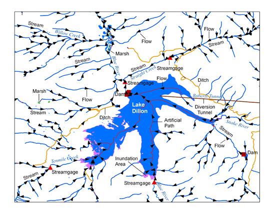
The USGS National Hydrography Dataset (NHD) service from The National Map (TNM) is a comprehensive set of digital spatial data that encodes information about naturally occurring and constructed bodies of surface water (lakes, ponds, and reservoirs), paths through which water flows (canals, ditches, streams, and rivers), and related entities such as point features (springs, wells, stream gages, and dams). The information encoded about these features includes classification and other characteristics, delineation, geographic name, position and related measures, a "reach code" through which other information can be related to the NHD, and the direction of water flow. The network of reach codes delineating water and...
Categories: Data;
Types: ArcGIS REST Map Service,
Map Service;
Tags: HU,
Hydrography,
NGP-TNM,
NHD,
Overlay Map Service,
|

|