Filters: Tags: broadleaf (X)
35 results (28ms)|
Filters
Date Range
Extensions (Less) Types (Less) Contacts (Less)
Categories (Less) Tag Types
|

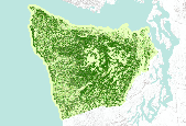
This theme shows broadleaf cover for the Coast Oregon physiographic province of the Interagency Vegetation Mapping Project (IVMP). The Interagency Vegetation Mapping Project (IVMP) provides maps of existing vegetation, canopy cover, size, and cover type for the entire range of the Northern Spotted Owl using satellite imagery from the Landsat Thematic Mapper (TM). This area is commonly called the FEMAT area, in reference to the area's analysis by the Forest Ecosystem Management Assessment Team. A regression modeling approach was used to predict vegetation characteristics from this Landsat data. This process involved the use of numerous sources of ancillary data, the most crucial being USFS, BLM, and Forest Inventory...
Background information.—Historically, the Powell River supported abundant and diverse populations of freshwater mussels. In recent decades, mussel density and species richness have declined and many freshwater mussel species are listed as either State or Federally threatened or endangered species. Environmental degradation from coal mining has been identified as one of the drivers of this decline. An example is the 1996 Lone Mountain slurry spill that directly affected mussel populations, as well as their host fish species. Freshwater mussels feed by filtering small particles from water, thereby improving water quality and providing an essential ecosystem service in rivers and streams. Mussels also serve as a food...
Categories: Project;
Types: Map Service,
OGC WFS Layer,
OGC WMS Layer,
OGC WMS Service;
Tags: Aquatic,
Aquatic species propagation,
Bank stabilization/erosion control,
Broadleaf,
Conservation easement,
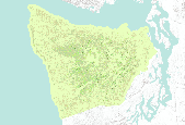
This theme shows broadleaf cover for the Coast Oregon physiographic province of the Interagency Vegetation Mapping Project (IVMP). The Interagency Vegetation Mapping Project (IVMP) provides maps of existing vegetation, canopy cover, size, and cover type for the entire range of the Northern Spotted Owl using satellite imagery from the Landsat Thematic Mapper (TM). This area is commonly called the FEMAT area, in reference to the area's analysis by the Forest Ecosystem Management Assessment Team. A regression modeling approach was used to predict vegetation characteristics from this Landsat data. This process involved the use of numerous sources of ancillary data, the most crucial being USFS, BLM, and Forest Inventory...

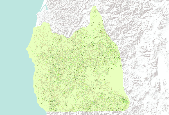
This theme shows broadleaf cover for the Coast Oregon physiographic province of the Interagency Vegetation Mapping Project (IVMP). The Interagency Vegetation Mapping Project (IVMP) provides maps of existing vegetation, canopy cover, size, and cover type for the entire range of the Northern Spotted Owl using satellite imagery from the Landsat Thematic Mapper (TM). This area is commonly called the FEMAT area, in reference to the area's analysis by the Forest Ecosystem Management Assessment Team. A regression modeling approach was used to predict vegetation characteristics from this Landsat data. This process involved the use of numerous sources of ancillary data, the most crucial being USFS, BLM, and Forest Inventory...

The Interagency Vegetation Mapping Project (IVMP) provides maps of existing vegetation, canopy cover, size, and cover type for the entire range of the Northern Spotted Owl using satellite imagery from the Landsat Thematic Mapper (TM). This area is commonly called the FEMAT area, in reference to the area's analysis by the Forest Ecosystem Management Assessment Team. A regression modeling approach was used to predict vegetation characteristics from this Landsat data. This process involved the use of numerous sources of ancillary data, the most crucial being USFS, BLM, and Forest Inventory and Analysis (FIA) plot field data and plot photo interpreted information. This data served as training data in the regression...
Background information.— The Powell and Clinch Rivers provide vital habitat for many forms of wildlife and are inhabited by one of the world’s richest and most diverse assemblages of freshwater mussels (U.S. Fish and Wildlife Service, 2003). The rivers are also multiple-use recreation areas and a valuable water source that supplies water for the residents of Lee County, Virginia. The Lone Mountain coal slurry spill released sediment and hazardous substances affecting water quality and impacting 12 Federally listed mussels and critical habitat for 2 Federally listed fish. Fish and mussel habitat depends on the riparian habitats surrounding the river. In order to recover lost fish and mussel habitat, the Lone Mountain...

The Interagency Vegetation Mapping Project (IVMP) provides maps of existing vegetation, canopy cover, size, and cover type for the entire range of the Northern Spotted Owl using satellite imagery from the Landsat Thematic Mapper (TM). This area is commonly called the FEMAT area, in reference to the area's analysis by the Forest Ecosystem Management Assessment Team. A regression modeling approach was used to predict vegetation characteristics from this Landsat data. This process involved the use of numerous sources of ancillary data, the most crucial being USFS, BLM, and Forest Inventory and Analysis (FIA) plot field data and plot photo interpreted information. This data served as training data in the regression...
The Interagency Vegetation Mapping Project (IVMP) provides maps of existing vegetation, canopy cover, size, and cover type for the entire range of the Northern Spotted Owl using satellite imagery from the Landsat Thematic Mapper (TM). This area is commonly called the FEMAT area, in reference to the area's analysis by the Forest Ecosystem Management Assessment Team. A regression modeling approach was used to predict vegetation characteristics from this Landsat data. This process involved the use of numerous sources of ancillary data, the most crucial being USFS, BLM, and Forest Inventory and Analysis (FIA) plot field data and plot photo interpreted information. This data served as training data in the regression...

The Interagency Vegetation Mapping Project (IVMP) provides maps of existing vegetation, canopy cover, size, and cover type for the entire range of the Northern Spotted Owl using satellite imagery from the Landsat Thematic Mapper (TM). This area is commonly called the FEMAT area, in reference to the area's analysis by the Forest Ecosystem Management Assessment Team. A regression modeling approach was used to predict vegetation characteristics from this Landsat data. This process involved the use of numerous sources of ancillary data, the most crucial being USFS, BLM, and Forest Inventory and Analysis (FIA) plot field data and plot photo interpreted information. This data served as training data in the regression...

The Interagency Vegetation Mapping Project (IVMP) provides maps of existing vegetation, canopy cover, size, and cover type for the entire range of the Northern Spotted Owl using satellite imagery from the Landsat Thematic Mapper (TM). This area is commonly called the FEMAT area, in reference to the area's analysis by the Forest Ecosystem Management Assessment Team. A regression modeling approach was used to predict vegetation characteristics from this Landsat data. This process involved the use of numerous sources of ancillary data, the most crucial being USFS, BLM, and Forest Inventory and Analysis (FIA) plot field data and plot photo interpreted information. This data served as training data in the regression...

The Interagency Vegetation Mapping Project (IVMP) provides maps of existing vegetation, canopy cover, size, and cover type for the entire range of the Northern Spotted Owl using satellite imagery from the Landsat Thematic Mapper (TM). This area is commonly called the FEMAT area, in reference to the area's analysis by the Forest Ecosystem Management Assessment Team. A regression modeling approach was used to predict vegetation characteristics from this Landsat data. This process involved the use of numerous sources of ancillary data, the most crucial being USFS, BLM, and Forest Inventory and Analysis (FIA) plot field data and plot photo interpreted information. This data served as training data in the regression...

This theme shows broadleaf cover for the Coast Oregon physiographic province of the Interagency Vegetation Mapping Project (IVMP). The Interagency Vegetation Mapping Project (IVMP) provides maps of existing vegetation, canopy cover, size, and cover type for the entire range of the Northern Spotted Owl using satellite imagery from the Landsat Thematic Mapper (TM). This area is commonly called the FEMAT area, in reference to the area's analysis by the Forest Ecosystem Management Assessment Team. A regression modeling approach was used to predict vegetation characteristics from this Landsat data. This process involved the use of numerous sources of ancillary data, the most crucial being USFS, BLM, and Forest Inventory...
The Interagency Vegetation Mapping Project (IVMP) provides maps of existing vegetation, canopy cover, size, and cover type for the entire range of the Northern Spotted Owl using satellite imagery from the Landsat Thematic Mapper (TM). This area is commonly called the FEMAT area, in reference to the area's analysis by the Forest Ecosystem Management Assessment Team. A regression modeling approach was used to predict vegetation characteristics from this Landsat data. This process involved the use of numerous sources of ancillary data, the most crucial being USFS, BLM, and Forest Inventory and Analysis (FIA) plot field data and plot photo interpreted information. This data served as training data in the regression...

The Interagency Vegetation Mapping Project (IVMP) provides maps of existing vegetation, canopy cover, size, and cover type for the entire range of the Northern Spotted Owl using satellite imagery from the Landsat Thematic Mapper (TM). This area is commonly called the FEMAT area, in reference to the area's analysis by the Forest Ecosystem Management Assessment Team. A regression modeling approach was used to predict vegetation characteristics from this Landsat data. This process involved the use of numerous sources of ancillary data, the most crucial being USFS, BLM, and Forest Inventory and Analysis (FIA) plot field data and plot photo interpreted information. This data served as training data in the regression...

This theme shows broadleaf cover for the Coast Oregon physiographic province of the Interagency Vegetation Mapping Project (IVMP). The Interagency Vegetation Mapping Project (IVMP) provides maps of existing vegetation, canopy cover, size, and cover type for the entire range of the Northern Spotted Owl using satellite imagery from the Landsat Thematic Mapper (TM). This area is commonly called the FEMAT area, in reference to the area's analysis by the Forest Ecosystem Management Assessment Team. A regression modeling approach was used to predict vegetation characteristics from this Landsat data. This process involved the use of numerous sources of ancillary data, the most crucial being USFS, BLM, and Forest Inventory...

This theme shows broadleaf cover for the Coast Oregon physiographic province of the Interagency Vegetation Mapping Project (IVMP). The Interagency Vegetation Mapping Project (IVMP) provides maps of existing vegetation, canopy cover, size, and cover type for the entire range of the Northern Spotted Owl using satellite imagery from the Landsat Thematic Mapper (TM). This area is commonly called the FEMAT area, in reference to the area's analysis by the Forest Ecosystem Management Assessment Team. A regression modeling approach was used to predict vegetation characteristics from this Landsat data. This process involved the use of numerous sources of ancillary data, the most crucial being USFS, BLM, and Forest Inventory...
The Interagency Vegetation Mapping Project (IVMP) provides maps of existing vegetation, canopy cover, size, and cover type for the entire range of the Northern Spotted Owl using satellite imagery from the Landsat Thematic Mapper (TM). This area is commonly called the FEMAT area, in reference to the area's analysis by the Forest Ecosystem Management Assessment Team. A regression modeling approach was used to predict vegetation characteristics from this Landsat data. This process involved the use of numerous sources of ancillary data, the most crucial being USFS, BLM, and Forest Inventory and Analysis (FIA) plot field data and plot photo interpreted information. This data served as training data in the regression...

The Interagency Vegetation Mapping Project (IVMP) provides maps of existing vegetation, canopy cover, size, and cover type for the entire range of the Northern Spotted Owl using satellite imagery from the Landsat Thematic Mapper (TM). This area is commonly called the FEMAT area, in reference to the area's analysis by the Forest Ecosystem Management Assessment Team. A regression modeling approach was used to predict vegetation characteristics from this Landsat data. This process involved the use of numerous sources of ancillary data, the most crucial being USFS, BLM, and Forest Inventory and Analysis (FIA) plot field data and plot photo interpreted information. This data served as training data in the regression...

This theme shows broadleaf cover for the Coast Oregon physiographic province of the Interagency Vegetation Mapping Project (IVMP). The Interagency Vegetation Mapping Project (IVMP) provides maps of existing vegetation, canopy cover, size, and cover type for the entire range of the Northern Spotted Owl using satellite imagery from the Landsat Thematic Mapper (TM). This area is commonly called the FEMAT area, in reference to the area's analysis by the Forest Ecosystem Management Assessment Team. A regression modeling approach was used to predict vegetation characteristics from this Landsat data. This process involved the use of numerous sources of ancillary data, the most crucial being USFS, BLM, and Forest Inventory...

The Interagency Vegetation Mapping Project (IVMP) provides maps of existing vegetation, canopy cover, size, and cover type for the entire range of the Northern Spotted Owl using satellite imagery from the Landsat Thematic Mapper (TM). This area is commonly called the FEMAT area, in reference to the area's analysis by the Forest Ecosystem Management Assessment Team. A regression modeling approach was used to predict vegetation characteristics from this Landsat data. This process involved the use of numerous sources of ancillary data, the most crucial being USFS, BLM, and Forest Inventory and Analysis (FIA) plot field data and plot photo interpreted information. This data served as training data in the regression...
|

|
