Filters: Tags: Water levels (X) > Types: Citation (X)
13 results (25ms)|
Filters
Date Range
Extensions Types
Contacts
Categories Tag Types
|
The maximum, and 80th, 90th, and 96th percentiles of the annual maximums of daily water levels recorded at monitoring sites in and near Miami-Dade County, Florida, during the 1974-2009 water years. [≥, greater than or equal to; %, percent; GW, groundwater; NPS, National Park Service; SFWMD, South Florida Water Management District; USGS, U.S. Geological Survey. All data adjusted to the North American Vertical Datum of 1988. Latitude and longitude are in decimal degrees]
Categories: Data;
Types: Citation;
Tags: Biscayne Bay,
Biscayne aquifer,
Contours,
Florida,
Inland Waters,
Changes in the Earth’s climate are expected to impact freshwater habitats around the world by altering water temperatures, water levels, and streamflow. These changes will have consequences for inland fish – those found within lakes, rivers, streams, canals, reservoirs, and other landlocked waters – which are important for food, commerce, and recreation around the world. According to the U.S. Fish and Wildlife Service, in 2011, 33.1 million people fished and spent $41.8 billion in the United States alone. Yet to date, little comprehensive research has been conducted to investigate the effects of climate change on inland fisheries at a large scale. The aim of this project was to summarize the current state of knowledge,...
Categories: Publication;
Types: Citation;
Tags: Fish,
National CASC,
Science Tools For Managers,
State of the Science,
Wildlife and Plants,
Statistical analyses and maps representing mean, high, and low water-level conditions in the surface water and groundwater of Miami-Dade County were made by the U.S. Geological Survey, in cooperation with the Miami-Dade County Department of Regulatory and Economic Resources, to help inform decisions necessary for urban planning and development. Sixteen maps were created that show contours of (1) the mean of daily water levels at each site during October and May for the 2000-2009 water years; (2) the 25th, 50th, and 75th percentiles of the daily water levels at each site during October and May and for all months during 2000-2009; and (3) the differences between mean October and May water levels, as well as the differences...
Dataset includes continuous discharge at the USGS (Station ID: 05485605) Fourmile Creek near Ankeny, IA DS1 gage site (http://waterdata.usgs.gov/usa/nwis/uv?site_no=05485605) as well as daily precipitation and water level data in select groundwater piezometers recorded in 10 minute intervals during the period Oct 1, 2013 to November 30 2013. Latitude and longitude data are provided for groundwater piezometer locations. This data release supports the following publication: Hubbard, L.E., S.H. Keefe, D.W. Kolpin, L.B. Barber, J.W. Duris, K.J. Hutchinson, and P.M. Bradley. Hydrologic Impact of Wastewater Contribution to Shallow Groundwater: Before and After Wastewater Discharge Cessation. Environmental Science: Water...
Categories: Data;
Types: Citation,
Map Service,
OGC WFS Layer,
OGC WMS Layer,
OGC WMS Service;
Tags: Iowa,
USGS Science Data Catalog (SDC),
Water Resources,
groundwater,
hydrology,
Statistics of daily water levels recorded at monitoring sites in or near Miami-Dade County, Florida, during the 1974—2009 water years ( a period of 13,149 days). [GW, groundwater; NPS, National Park Service; SFWMD, South Florida Water Management District; SW, surface water; USGS, U.S. Geological Survey. All data adjusted to the North American Vertical Datum of 1988. Latitude and longitude are in decimal degrees.]
Categories: Data;
Types: Citation;
Tags: Biscayne Bay,
Biscayne aquifer,
Contours,
Florida,
Inland Waters,
Statistical analyses and maps representing mean, high, and low water-level conditions in the surface water and groundwater of Miami-Dade County were made by the U.S. Geological Survey, in cooperation with the Miami-Dade County Department of Regulatory and Economic Resources, to help inform decisions necessary for urban planning and development. Sixteen maps were created that show contours of (1) the mean of daily water levels at each site during October and May for the 2000-2009 water years; (2) the 25th, 50th, and 75th percentiles of the daily water levels at each site during October and May and for all months during 2000-2009; and (3) the differences between mean October and May water levels, as well as the differences...
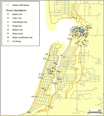
This data set is a point shapefile representing observations of inundation and water levels from the Alaska 1964 event obtained by Tom Horning (1997). The geospatial dataset were derived from a spreadsheet provided by Bruce Jaffe.
Categories: Data;
Types: Citation,
Downloadable,
Map Service,
OGC WFS Layer,
OGC WMS Layer,
Shapefile;
Tags: Oregon,
Seaside, Oregon,
USA,
observations,
tsunami inundation,
Statistics of daily water levels recorded during the 1990—2009 water years used to create maps of the water table in Miami-Dade County, Florida. [USGS, U.S. Geological Survey; All data adjusted to the North American Vertical Datum of 1988 (NAVD 88). Latitude and longitude are in decimal degrees. See appendix 8 for index map]
Categories: Data;
Types: Citation;
Tags: Biscayne Bay,
Biscayne aquifer,
Contours,
Florida,
Inland Waters,
Statistical analyses and maps representing mean, high, and low water-level conditions in the surface water and groundwater of Miami-Dade County were made by the U.S. Geological Survey, in cooperation with the Miami-Dade County Department of Regulatory and Economic Resources, to help inform decisions necessary for urban planning and development. Sixteen maps were created that show contours of (1) the mean of daily water levels at each site during October and May for the 2000-2009 water years; (2) the 25th, 50th, and 75th percentiles of the daily water levels at each site during October and May and for all months during 2000-2009; and (3) the differences between mean October and May water levels, as well as the differences...
Excel table providing the daily water level data from the National Park Service, Everglades National Park, the South Florida Water Management District, and the U.S. Geological Survey during 1974-2009 prior to editing. [All data are in the original vertical datum provided by the collecting organizations (see row titled "Datum"). Data were retrieved from the databases of the National Park Service - Everglades National Park, South Florida Water Management District, and U.S. Geological Survey in July and August 2012. The row titled "Notes" describes the subsequent changes that were made during editing in 2012, such as the elimination of redundant or unusable site files and merging of datasets collected at the same site....
Categories: Data;
Types: Citation;
Tags: Biscayne Bay,
Biscayne aquifer,
Contours,
Florida,
Inland Waters,
Changes in tidal marsh area and habitat type in response to sea-level rise were modeled using the Sea Level Affecting Marshes Model (SLAMM 6) that accounts for the dominant processes involved in wetland conversion and shoreline modifications during long-term sea level rise (Park et al. 1989; Successive versions of the model have been used to estimate the impacts of sea level rise on the coasts of the U.S. The model was produced by Warren Pinnacle Consulting, Inc. for the U.S. Fish and Wildlife Service. The SLAMM version 6 technical document can be accessed at http://warrenpinacle.com/prof/SLAMM. SLAMM outputs were converted from raster to vector features. Land cover (wetland) types were generalized to MesoHabitat...
Categories: Data;
Types: ArcGIS REST Map Service,
ArcGIS Service Definition,
Citation,
Downloadable,
Map Service;
Tags: LiDAR,
Port Aransas,
SLAMM,
SLR,
Sea Level,
Edited daily water-level data recorded at monitoring sites in and near Miami-Dade County, Florida, during the 1974-2009 water years. [All data have been converted from the original vertical datum to the North American Vertical Datum of 1988 (NAVD 88). The row titled "Notes" describes some of the changes that were made, such as merging of data from the same site and deletion of anomalous data. Latitude and longitude are in decimal degrees. Dates are in month/day/year format. Abbreviations: FT, foot; NGVD 29, National Geodetic Vertical Datum of 1929; NAVD 88, North American Vertical Datum of 1988; NPS, National Park Service; SFWMD, South Florida Water Management; USGS, U.S. Geological Survey]
Categories: Data;
Types: Citation;
Tags: Biscayne Bay,
Biscayne aquifer,
Contours,
Florida,
Inland Waters,
Description of columns in the ArcGIS point file "Points for Maps" which provides the final statistics used to make the maps of mean daily water levels and maps of the 25th, 50th, and 75th percentiles of daily water levels during 2000–2009 in Miami-Dade County; and maps showing the differences in the statistics of water levels between 1990–1999 and 2000–2009.
Categories: Data;
Types: Citation;
Tags: Biscayne Bay,
Biscayne aquifer,
Contours,
Florida,
Inland Waters,
|

|
