Filters: Tags: Protected Areas (X)
312 results (29ms)|
Filters
|

Protected areas are cornerstones of national and international conservation strategies. By way of these designations, lands and waters are set-aside in-perpetuity to preserve functioning natural ecosystems, act as refuges for species, and maintain ecological processes. Complementary conservation strategies preserve land for the sustainable use of natural resources, or for the protection of significant geologic and cultural features or open space. PAD-US 1.1 (CBI Edition) attempts to include all available spatial data on these places. It is our goal to publish the most comprehensive geospatial data set of U. S. protected areas to date. PAD-US 1.1 (CBI Edition) is limited to the continental U.S., Alaska, and Hawaii....

These protected areas were estimated by the Conservation Biology Institute as being most immediately threatened by the corresponding Deepwater Horizon oil spill trajectory forecast in the Gulf of Mexico. This dataset is extracted from PAD-US 1.1 (CBI Edition), and the original metadata has been included here, below. First, protected areas within 1 mile of the entire study area coastline (TX to NJ), or that intersect hydrological feature polygons from the NHDPlus National Hydrography Dataset within the 1-mile coastline buffer, were extracted from PAD-US 1.1 (CBI Edition). Then, protected areas were identified as being under primary, secondary, or tertiary threat from the oil spill. The probability of being affected...

These data are an extraction of IUCN 1a, 1b and II from Canada Protected Areas based on the Commission for Environmental Cooperation, updated to Dec 31, 2012.

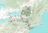
This dataset is an extract of the full PAD-US (CBI Edition) Version 2 for Virginia. For more information about this dataset, and to download the full US dataset, please go to: http://consbio.org/products/projects/pad-us-cbi-edition PAD-US (CBI Edition) Version 2 is a national database of protected fee lands in the United States. PAD-US (CBI Edition) Version 2 has been redesigned to be used along with the National Conservation Easement Database (NCED) , to visualize the entire terrestrial conservation estate of the United States. PAD-US (CBI Edition) Version 2 is limited to the continental U.S., Alaska, and Hawaii. It does not include protected areas data for U.S. territories at this time. Protected areas are...
This dataset is an extract of the full PAD-US (CBI Edition) Version 2 for New York. For more information about this dataset, and to download the full US dataset, please go to: http://consbio.org/products/projects/pad-us-cbi-edition PAD-US (CBI Edition) Version 2 is a national database of protected fee lands in the United States. PAD-US (CBI Edition) Version 2 has been redesigned to be used along with the National Conservation Easement Database (NCED) , to visualize the entire terrestrial conservation estate of the United States. PAD-US (CBI Edition) Version 2 is limited to the continental U.S., Alaska, and Hawaii. It does not include protected areas data for U.S. territories at this time. Protected areas are cornerstones...

These data area an extraction from PAD-US (CBI Edition) Version 2 of Area of Critical Environmental Concern (ACEC). PAD-US (CBI Edition) Version 2 is a national database of protected fee lands in the United States. PAD-US (CBI Edition) Version 2 has been redesigned to be used along with the National Conservation Easement Database (NCED), to visualize the entire terrestrial conservation estate of the United States. PAD-US (CBI Edition) Version 2 is limited to the continental U.S., Alaska, and Hawaii. It does not include protected areas data for U.S. territories at this time. Protected areas are cornerstones of national and international conservation strategies. By way of these designations, lands and waters are...

This dataset is an extract of the full PAD-US (CBI Edition) Version 2 for Alabama. For more information about this dataset, and to download the full US dataset, please go to: http://consbio.org/products/projects/pad-us-cbi-edition PAD-US (CBI Edition) Version 2 is a national database of protected fee lands in the United States. PAD-US (CBI Edition) Version 2 has been redesigned to be used along with the National Conservation Easement Database (NCED) , to visualize the entire terrestrial conservation estate of the United States. PAD-US (CBI Edition) Version 2 is limited to the continental U.S., Alaska, and Hawaii. It does not include protected areas data for U.S. territories at this time. Protected areas are cornerstones...

Utah Environmental Congress and Grand Canyon Trust's Unified Forest Service Wilderness Proposal for Beaver, Emery, Grand, Piute and San Juan and part of Sevier Counties, Utah The Unified Forest Wilderness Proposal represents the Utah Environmental Congress and Grand Canyon Trust’s proposed boundaries for inclusion in the National Wilderness Preservation System via an Act of Congress. The Unified Forest Wilderness Proposal represents the combination and unification of the Utah Environmental Congress and the Utah Forest Network wilderness proposals, both of which were drafted in 2004 and 2005. The boundaries of the Unified Proposal were reviewed and updated in 2010, 2011 and 2012 using current agency and state...

Protected areas are cornerstones of national and international conservation strategies. By way of these designations, lands and waters are set-aside in-perpetuity to preserve functioning natural ecosystems, act as refuges for species, and maintain ecological processes. Complementary conservation strategies preserve land for the sustainable use of natural resources, or for the protection of significant geologic and cultural features or open space. PAD-US 1.1 (CBI Edition) attempts to include all available spatial data on these places. It is our goal to publish the most comprehensive geospatial data set of U. S. protected areas to date. PAD-US 1.1 (CBI Edition) is limited to the continental U.S., Alaska, and Hawaii....

This dataset is extracted from PAD-US 1.1 (CBI Edition), and the original metadata has been included here, below. These protected areas were roughly identified by the Conservation Biology Institute as being the most immediately threatened by the Deepwater Horizon oil spill in the Gulf of Mexico. The probability of being affected was determined using the University of South Florida's Deepwater Horizon oil spill trajectory forecast from the WFS ROMS numerical model, as projected for 06/11/2010 at 00h UTC (http://ocg6.marine.usf.edu/~liu/oil_spill_ensemble_forecast.html). For more information, please see the Oil Spill in the Gulf of Mexico page at Data Basin (http://www.databasin.org/aquatic-center/features/oil-spill...

This dataset is extracted from PAD-US 1.1 (CBI Edition), and the original metadata has been included here. These protected areas were roughly identified by the Conservation Biology Institute as being the "most immediately" threatened by the Deepwater Horizon oil spill in the Gulf of Mexico. The probability of being affected was determined using the University of South Florida's Deepwater Horizon oil spill trajectory forecast from the WFS ROMS numerical model, as projected for 05/31/2010 at 00h UTC (http://ocg6.marine.usf.edu/~liu/oil_spill_ensemble_forecast.html). For more information, please see the Oil Spill in the Gulf of Mexico page at Data Basin (http://www.databasin.org/aquatic-center/features/oil-spill...

(A newer version of these data is now available, Protected Areas - Kansas, October 2012 ) This dataset is an extraction from PAD-US 1.1 (CBI Edition), by state. The PAD-US 1.1 (CBI Edition) data set portrays the nation's protected areas with a standardized spatial geometry and numerous valuable attributes on land ownership, management designations, and conservation status (using national GAP and international IUCN coding systems). The PAD-US 1.1 (CBI Edition) defines protected areas to include all lands dedicated to the preservation of biological diversity and to other natural, recreation and cultural uses, and managed for these purposes through legal or other effective means (adapted from IUCN definition). The...

(A newer version of these data is now available, Protected Areas - Virginia, October 2012 ) This dataset is an extraction from PAD-US 1.1 (CBI Edition), by state. The PAD-US 1.1 (CBI Edition) data set portrays the nation's protected areas with a standardized spatial geometry and numerous valuable attributes on land ownership, management designations, and conservation status (using national GAP and international IUCN coding systems). The PAD-US 1.1 (CBI Edition) defines protected areas to include all lands dedicated to the preservation of biological diversity and to other natural, recreation and cultural uses, and managed for these purposes through legal or other effective means (adapted from IUCN definition). The...

(A newer version of these data is now available, Protected Areas - Colorado, October 2012 ) This dataset is an extraction from PAD-US 1.1 (CBI Edition), by state. The PAD-US 1.1 (CBI Edition) data set portrays the nation's protected areas with a standardized spatial geometry and numerous valuable attributes on land ownership, management designations, and conservation status (using national GAP and international IUCN coding systems). The PAD-US 1.1 (CBI Edition) defines protected areas to include all lands dedicated to the preservation of biological diversity and to other natural, recreation and cultural uses, and managed for these purposes through legal or other effective means (adapted from IUCN definition). The...

(A newer version of these data is now available, Protected Areas - Kentucky, October 2012 ) This dataset is an extraction from PAD-US 1.1 (CBI Edition), by state. The PAD-US 1.1 (CBI Edition) data set portrays the nation's protected areas with a standardized spatial geometry and numerous valuable attributes on land ownership, management designations, and conservation status (using national GAP and international IUCN coding systems). The PAD-US 1.1 (CBI Edition) defines protected areas to include all lands dedicated to the preservation of biological diversity and to other natural, recreation and cultural uses, and managed for these purposes through legal or other effective means (adapted from IUCN definition). The...
PAD-US (CBI Edition) Version 2 is a national database of protected fee lands in the United States. PAD-US (CBI Edition) Version 2 has been redesigned to be used along with the National Conservation Easement Database (NCED), to visualize the entire terrestrial conservation estate of the United States. PAD-US (CBI Edition) Version 2 is limited to the continental U.S., Alaska, and Hawaii. It does not include protected areas data for U.S. territories at this time.Protected areas are cornerstones of national and international conservation strategies. By way of these designations, lands and waters are set aside in-perpetuity to preserve functioning natural ecosystems, act as refuges for species, and maintain ecological...

(A newer version of these data is now available, Protected Areas - Delaware, October 2012 ) This dataset is an extraction from PAD-US 1.1 (CBI Edition), by state. The PAD-US 1.1 (CBI Edition) data set portrays the nation's protected areas with a standardized spatial geometry and numerous valuable attributes on land ownership, management designations, and conservation status (using national GAP and international IUCN coding systems). The PAD-US 1.1 (CBI Edition) defines protected areas to include all lands dedicated to the preservation of biological diversity and to other natural, recreation and cultural uses, and managed for these purposes through legal or other effective means (adapted from IUCN definition). The...
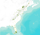
This polygon data set includes the protected areas of the Eastern United States of America that are managed by national, state, provincial, or territorial authorities. As defined by the International Union for the Conservation of Nature (IUCN), a protected area is an area of land and/or sea especially dedicated to the protection and maintenance of biological diversity, and of natural and associated cultural resources, and managed through legal or other effective means. The data set was assembled for the Commission for Environmental Cooperation (CEC) from other public data sets containing data on protected areas in Canada, Mexico, and the United States. Protected area data was obtained from Natural Resources Canada...

The datatset is a compilation of all permanent (legally established) protected areas in Northwest Territories, Canada.

This dataset gives a rough approximation of where oil from the BP Deepwater Horizon oil spill has made landfall along the Gulf Coast, with the most recent projections added for July 16, 2010. This data is intended only to give a general idea of the scope of the the oil spill, and not to make specific or detailed analyses of oil spill landfall.
|

|
