Filters: Tags: Critical habitat (X)
70 results (13ms)|
Filters
Date Range
Extensions (Less) Types (Less)
Contacts (Less)
Categories (Less) Tag Types
|

These data identify the areas where final critical habitat has been mapped by the USFWS for plant species in the eastern United States. These data were compiled by the Conservation Biology Institute (CBI) from a series of individual shapefiles published by the USFWS (http://criticalhabitat.fws.gov/). For more information on the process for mapping the critical habitat for each species, please see the metadata for each species listed on the USFWS web site. Critical habitat designations have not been made for all listed endangered species. Where critical habitat has been mapped, this dataset only contains those species for which GIS datasets have been made publicly available. Other critical habitat maps exist for...
This is a web map service from the USFWS. It contains multiple layers related to final critical habitat for threatened and endangered species. Critical habitat are areas considered essential for the conservation of a listed species. These datasets include both line and polygon features.More information can be found here: http://criticalhabitat.fws.gov/crithab/

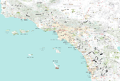
These data identify the areas (in general) where critical habitat for tidewater goby occurs. Critical habitat for the species consists of approximately 10,000 acres among 44 units distributed along the coast from Los Angeles County northward to Del Norte County, California.

These data identify the areas where final critical habitat has been mapped by the USFWS for invertebrate species. These data were compiled by the Conservation Biology Institute (CBI) from a series of individual shapefiles published by the USFWS (http://criticalhabitat.fws.gov/). For more information on the process for mapping the critical habitat for each species, please see the metadata for each species listed on the USFWS web site. This particular dataset contains the fish species critical habitat areas that are represented by polygons. Critical habitat represented by lines are contained in a separate dataset. Critical habitat designations have not been made for all listed endangered species. Where critical habitat...

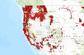
These data identify the areas where final critical habitat has been mapped by the USFWS for plant species in the western United States. These data were compiled by the Conservation Biology Institute (CBI) from a series of individual shapefiles published by the USFWS (http://criticalhabitat.fws.gov/). For more information on the process for mapping the critical habitat for each species, please see the metadata for each species listed on the USFWS web site. Critical habitat designations have not been made for all listed endangered species. Where critical habitat has been mapped, this dataset only contains those species for which GIS datasets have been made publicly available. Other critical habitat maps exist for...
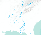
Critical habitat lines - Mississippi River BasinWhen a species is proposed for listing as endangered or threatened under the Endangered Species Act, the U.S. Fish and Wildlife Service must consider whether there are areas of habitat believed to be essential the species’ conservation. Those areas may be proposed for designation as “critical habitat.” Critical habitat is a term defined and used in the Act. It is a specific geographic area(s) that contains features essential for the conservation of a threatened or endangered species and that may require special management and protection. Critical habitat may include an area that is not currently occupied by the species but that will be needed for its recovery. An area...
Categories: Data;
Types: Citation,
Downloadable,
Map Service,
OGC WFS Layer,
OGC WMS Layer,
Shapefile;
Tags: Biota,
Critical Habitat,
Endangered species,
Listed species,
Threatened species,
When a species is proposed for listing as endangered or threatened under the Endangered Species Act, the U.S. Fish and Wildlife Service must consider whether there are areas of habitat believed to be essential the species’ conservation. Those areas may be proposed for designation as “critical habitat.” Critical habitat is a term defined and used in the Act. It is a specific geographic area(s) that contains features essential for the conservation of a threatened or endangered species and that may require special management and protection. Critical habitat may include an area that is not currently occupied by the species but that will be needed for its recovery. An area is designated as “critical habitat” after the...
Categories: Data;
Types: ArcGIS REST Map Service,
ArcGIS Service Definition,
Citation,
Downloadable,
Map Service;
Tags: Alabama,
Alaska,
Arizona,
Arkansas,
Biota,
These data identify the areas where final critical habitat has been mapped by the USFWS for invertebrate species. These data were compiled by the Conservation Biology Institute (CBI) from a series of individual shapefiles published by the USFWS (http://criticalhabitat.fws.gov/). For more information on the process for mapping the critical habitat for each species, please see the metadata for each species listed on the USFWS web site. This particular dataset contains the invertebrate species critical habitat areas that are represented by lines. Critical habitat represented by polygons are contained in a separate dataset. Critical habitat designations have not been made for all listed endangered species. Where critical...

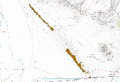
These data identify the areas (in general) where critical habitat for Braunton's milk-vetch occurs. Critical habitat for the species consists of approximately 3,300 acres among six units distributed in three general areas: eastern Ventura County, east-central Los Angeles County, and northeastern Orange County, California.

These data identify, in general, the areas where final critical habitat exist for species listed as endangered or threatened.

This dataset depicts counties in the United States which contain Canada Lynx (Lynx canadensis) critical habitat proposed by the U.S. Fish and Wildlife Service (USFWS) in the Federal Register February 28, 2008. Critical habitat maps were only available for this species in non-spatial image format from the Federal Register, for the proposed critical habitat published on February 28, 2008. The Conservation Biology Institute obtained these images and geo-rectified them to a U.S. counties dataset published by the U.S. Census Bureau. This dataset DOES NOT represent critical habitat as mapped by the USFWS, but is rather an unofficial approximation of critical habitat.
Tags: canada lynx,
critical habitat

These data identify, in general, the areas where revised critical habitat for the Santa Ana sucker (Catostomus santaanae) has been designated.
These data identify the areas (in general) of critical habitat designated for the arroyo toad. NOTE: THIS DATA SET INCLUDES APPROXIMATELY 900 ACRES OF LAND INADVERTENTLY OMMITTED FROM THE MAPS AND LEGAL DESCRIPTIONS FOR UNITS 8, 10, 11, AND 14 IN THE FINAL RULE PUBLISHED ON FEBRUARY 9, 2011 (76FR7246). UNTIL A CORRECTION OF THE FINAL RULE IS PUBLISHED THE BOUNDARIES OF UNITS 8, 10, 11 AND 14 SHOULD BE CONSIDERED PROVISIONAL. These data reflect revisions to the proposal published in the Federal Register on October 13, 2009 (74FR52614). Critical habitat for the species consists of approximately 98,000 acres among 22 units from San Diego County northward to Santa Barbara County, California. Descriptions of the units...

Proposed revised critical habitat for the pacific coast western snowy plover. This dataset was created to revise the 2005 final critical habitat rule for the species. This dataset includes polygon features representing proposed unit boundaries and exempted unit boundaries from Washington, Oregon, and California. There are 55 units, some containing from 2 to 10 sub-units. The units are identified by state, unit number, and sub-unit alpha character. Unit boundaries were compiled from data developed in several field offices, including the Western Washington Fish and Wildlife Office (FWO) in Lacey, WA; the Newport Field Office, Newport, OR; the Arcata FWO, Arcata CA; the Sacramento FWO, Sacramento, CA; the Ventura FWO...
From USFWS service description: "This data service identifies, in general, the areas where final critical habitat exist for species that are endangered or threatened. Special protections and/or restrictions are possible in areas where federal funding, permits, licenses, authorizations or actions occur or are required. Critical habitat are areas considered essential for the conservation of a listed species. These areas provide notice to the public and land managers the importance of these areas to the conservation of the species." The data can be downloaded in a shapefile, viewed on the Fish and Wildlife Service's map viewer, or accessed through a web service. It's also possible to view the data through the ScienceBase...
Categories: Data,
Web Site;
Types: ArcGIS REST Map Service,
Map Service,
OGC WMS Layer,
OGC WMS Service;
Tags: Critical Habitat,
Final Rule,
U.S. Fish and Wildlife Service,
USFWS
When a species is proposed for listing as endangered or threatened under the Endangered Species Act, the U.S. Fish and Wildlife Service must consider whether there are areas of habitat believed to be essential the species’ conservation. Those areas may be proposed for designation as “critical habitat.” Critical habitat is a term defined and used in the Act. It is a specific geographic area(s) that contains features essential for the conservation of a threatened or endangered species and that may require special management and protection. Critical habitat may include an area that is not currently occupied by the species but that will be needed for its recovery. An area is designated as “critical habitat” after the...
Categories: Data;
Types: ArcGIS REST Map Service,
ArcGIS Service Definition,
Citation,
Downloadable,
Map Service;
Tags: Alabama,
Alaska,
Arizona,
Arkansas,
Biota,

These data identify the areas where final critical habitat has been mapped by the USFWS for reptile species. These data were compiled by the Conservation Biology Institute (CBI) from a series of individual shapefiles published by the USFWS (http://criticalhabitat.fws.gov/). For more information on the process for mapping the critical habitat for each species, please see the metadata for each species listed on the USFWS web site. Critical habitat designations have not been made for all listed endangered species. Where critical habitat has been mapped, this dataset only contains those species for which GIS datasets have been made publicly available. Other critical habitat maps exist for some species in non-GIS formats...

These data identify the areas where final critical habitat has been mapped by the USFWS for amphibian species. These data were compiled by the Conservation Biology Institute (CBI) from a series of individual shapefiles published by the USFWS (http://criticalhabitat.fws.gov/). For more information on the process for mapping the critical habitat for each species, please see the metadata for each species listed on the USFWS web site. Critical habitat designations have not been made for all listed endangered species. Where critical habitat has been mapped, this dataset only contains those species for which GIS datasets have been made publicly available. Other critical habitat maps exist for some species in non-GIS formats...
These data identify, in general, the areas where designated critical habitat for Peirson's milk-vetch (Astragalus magdalenae var. peirsonii) occur.

These data identify the areas where final critical habitat has been mapped by the USFWS for plant species in the Pacific islands of the United States. These data were compiled by the Conservation Biology Institute (CBI) from a series of individual shapefiles published by the USFWS (http://criticalhabitat.fws.gov/). For more information on the process for mapping the critical habitat for each species, please see the metadata for each species listed on the USFWS web site. Critical habitat designations have not been made for all listed endangered species. Where critical habitat has been mapped, this dataset only contains those species for which GIS datasets have been made publicly available. Other critical habitat...
|

|
