Filters: Tags: Corridors (X)
49 results (44ms)|
Filters
Contacts
(Less)
|
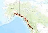
Rights of Way Corridors
Categories: Data;
Types: Downloadable;
Tags: BLM,
Corridors,
Federal Government,
Lands and Realty,
ROW,
Subalpine Connectivity of areas of high elevation and high human footprint in the North Pacific Landscape Conservation Cooperative study area. This application provides Subalpine Connectivity for 2000 and 2080 (A1B). The North Pacific Forest Landscape Connectivity Project uses three main geospatial layers as inputs into the creation of resistance map grids.  One-km was decided as the resolution for the final resistance grids.  The three primary geospatial layers used in this analysis were a digital elevation model (DEM), a vegetation layer, and a human footprint layer.  Due to the geographic extent of the North Pacific Landscape Conservation Cooperative, digital elevation models from different sources had to...
Abstract: As the climate changes, human land use may impede species from tracking areas with suitable climates. Maintaining connectivity between areas of different temperatures could allow organisms to move along temperature gradients and allow species to continue to occupy the same temperature space as the climate warms. We used a coarse-filter approach to identify broad corridors for movement between areas where human influence is low while simultaneously routing the corridors along present-day spatial gradients of temperature. We modified a cost–distance algorithm to model these corridors and tested the model with data on current land-use and climate patterns in the Pacific Northwest of the United States. The...
Categories: Data,
Publication;
Types: Citation;
Tags: LCC Network Science Catalog,
Publication,
adaptation,
climatic gradients,
completed,
For more information about how these data were developed, please see the final report. Expert opinion was used to define a resistance surface for each of the target animals, with higher resistance representing map units expected to be more difficult and more dangerous for species to move through. A set of nodes for each species, with node points indicating center locations for potential source populations for the species, are also defined. Note actual species population data to define the nodes is not used, as that data was often unavailable, and the focus is on the potential spread of the species across the SALCC region and not limited to models to known populations. Therefore, node locations were determined by...
Categories: Data;
Types: ArcGIS REST Map Service,
ArcGIS Service Definition,
Downloadable,
Map Service;
Tags: Southeast,
black bear,
connectivity,
corridors,
future projection,
Conclusions:This report sets out guidelines intended to provide BCEAG member jurisdictions with a coordinated approach to recommendations regarding the management of human use activities within wildlife corridors and habitat patches in the Bow Valley of Alberta. The guidelines provide an advisory framework for decision making related to wildlife management as well as recommendations for mitigating the negative effects of human activity on wildlife in the region.Thresholds/Learnings:Male and female cougars avoided areas of high human use and where human use levels exceeded 250-500 users per month.
Categories: Publication;
Types: Citation;
Tags: Canadian Rockies,
Land use configuration,
Landscape fragmentation,
Natural cover amount,
Regional,
This dataset was created by overlaying connectivity model outputs for grizzly bear, black bear, lynx, wolverine, forest specialist species, and forest biome dwellers where they intersect the region’s major roads. It was used in conjunction with future traffic volume projections to identify priority sites for mitigating road impacts on wildlife. This project investigated the potential impacts of future housing development on traffic to determine where increased traffic from housing development will impact habitat connectivity for large carnivores. The focus of this study was Flathead and Lincoln counties in northwestern Montana. The main goal was to maintain wildlife habitat connectivity across transportation corridors...
Categories: Data;
Types: ArcGIS REST Map Service,
ArcGIS Service Definition,
Downloadable,
Map Service,
OGC WFS Layer,
OGC WMS Layer,
Shapefile;
Tags: Flathead County,
Lincoln County,
Northern Rocky Mountains,
Northwest Montana,
connectivity,
This layer provides information on putative winter corridors facilitating dispersal from northern populations to patches capable of supporting Canada lynx in the Northern Rocky Mountains. These results combine resource selection, step selection, and least-cost path models to define movement corridors for lynx in the Northern Rocky Mountains. The illustrated corridors were created by using a one-mile buffer around the putative winter corridors facilitating dispersal from northern populations to patches capable of supporting Canada lynx in the Northern Rocky Mountains
Categories: Data;
Types: Downloadable,
Map Service,
OGC WFS Layer,
OGC WMS Layer,
Shapefile;
Tags: Canada lynx,
Connectivity,
Corridors,
Least-cost paths,
Montana,
Climate changes impose requirements for many species to shift their ranges to remain within environmentally tolerable areas, but near-continuous regions of intense human land use stretching across continental extents diminish dispersal prospects for many species. We reviewed the impact of habitat loss and fragmentation on species? abilities to track changing climates and existing plans to facilitate species dispersal in response to climate change through regions of intensive land uses, drawing on examples from North America and elsewhere. We identified an emerging analytical framework that accounts for variation in species' dispersal capacities relative to both the pace of climate change and habitat availability....
Categories: Publication;
Types: Citation;
Tags: adaptive management,
cambio climático,
climate change,
corredores biológicos,
corridors,
The Sheldon-Hart Mountain pronghorn (Antilocapra americana) herd is part of a large interstate metapopulation distributed across northwest Nevada, southeast Oregon, and portions of northeast California. Some animals travel up to 100 miles between summer and winter ranges and traverse multiple federal land jurisdictions, including the Sheldon National Wildlife Refuge, Hart Mountain National Wildlife Refuge, and surrounding Bureau of Land Management (BLM) lands. The herd can be characterized as conditionally or partially migratory with approximately 65% of collared animals exhibiting migratory tendencies. Major summer ranges include portions of the Hart Mountain Wildlife Refuge, Sheldon National Wildlife Refuge, and...
Categories: Data;
Types: Downloadable,
Map Service,
OGC WFS Layer,
OGC WMS Layer,
Shapefile;
Tags: Lakeview,
Oregon,
United States,
animal behavior,
corridors,

Subalpine Connectivity of areas of low elevation and low human footprint in the North Pacific Landscape Conservation Cooperative study area. This application provides Subalpine Connectivity for 2000 and 2080 (A1B).The North Pacific Forest Landscape Connectivity Project uses three main geospatial layers as inputs into the creation of resistance map grids. One-km was decided as the resolution for the final resistance grids. The three primary geospatial layers used in this analysis were a digital elevation model (DEM), a vegetation layer, and a human footprint layer. Due to the geographic extent of the North Pacific Landscape Conservation Cooperative, digital elevation models from different sources had to be...
The connectivity result files from Circuitscape represent the "adjusted cumulative current density" flowing across the landscape for each of several species, at a 90-meter resolution across the South Atlantic Landscape Conservation Cooperative region. Rasters are classified using quantiles with 20 categories (each 5% of region) to integer scores from 1-20. 1 = lowest 5% of the landscape, 20= top 5% of landscape Expert opinion was used to define a resistance surface for each of the target animals, with higher resistance representing map units expected to be more difficult and dangerous for species to move through. A set of nodes for each species, with node points indicating center locations for potential source populations,...
Categories: Data;
Types: ArcGIS REST Map Service,
ArcGIS Service Definition,
Downloadable,
Map Service;
Tags: Eastern cougar,
Southeast,
connectivity,
corridors,
future projection,
This layer provides information on putative winter corridors facilitating dispersal from northern populations to patches capable of supporting Canada lynx in the Northern Rocky Mountains. These results combine resource selection, step selection, and least-cost path models to define movement corridors for lynx in the Northern Rocky Mountains.
Categories: Data;
Types: Downloadable,
Map Service,
OGC WFS Layer,
OGC WMS Layer,
Shapefile;
Tags: Canada lynx,
Connectivity,
Corridors,
Least-cost paths,
Montana,
Crucial stream/river corridors for aquatic species in Wyoming at a scale of 1:100,000. Data is current as of 2007; please check with the Wymoing Game and Fish Department for any potential updates to this dataset: https://wgfd.wyo.gov/Wildlife-in-Wyoming/Geospatial-Data/Habitat-GIS-Information
Categories: Data,
Publication;
Types: ArcGIS REST Map Service,
ArcGIS Service Definition,
Citation,
Downloadable,
Map Service;
Tags: Biota,
Corridors,
Crucial stream corridors,
Rivers,
Streams,

- Subalpine Connectivity of areas of high elevation and high human footprint in the North Pacific Landscape Conservation Cooperative study area. This application provides Subalpine Connectivity for 2000 and 2080 (A1B). The North Pacific Forest Landscape Connectivity Project uses three main geospatial layers as inputs into the creation of resistance map grids. One-km was decided as the resolution for the final resistance grids. The three primary geospatial layers used in this analysis were a digital elevation model (DEM), a vegetation layer, and a human footprint layer. Due to the geographic extent of the North Pacific Landscape Conservation Cooperative, digital elevation models from different sources had to...
WildLinks 2011 Conference brought together transboundary scientists and managers to share information on the latest science , policies, and efforts to address climate adaptation for species and habitats on both sides of the border.
Categories: Data,
Project;
Types: Map Service,
OGC WFS Layer,
OGC WMS Layer,
OGC WMS Service;
Tags: Academics & scientific researchers,
Adaptation planning,
B.C. North Cascades,
B.C. North Cascades,
B.C. North Cascades,
The Cascadia Parner Forum fosters a network of natural resource practitioners working with the NPLCC and GNLCC to guild the adaptive capacity of the landscape and species living within it. This project supported three complementary transboundary climate adaptation and habitat connectivity activities in the Cascadia region: 1) Transboundary Climate Analysis by the Washington Wildlife Habitat Connectivity Working Group, 2) WildLinks workshop, and 3) Cascadia Partner Forum.
Categories: Data;
Types: Map Service,
OGC WFS Layer,
OGC WMS Layer,
OGC WMS Service;
Tags: Academics & scientific researchers,
Adaptation planning,
B.C. North Cascades,
Cascadia,
Conservation Design,
At the statewide scale, we are looking for patterns of habitat distribution that dominate large landscapes. This can be thought of as a view of the land from 50,000 feet above the Earth’s surface. This view is interpreted through the behaviors and natural histories of some of Washington’s more mobile vertebrate wildlife, using computer models and our best understanding of what influences these species in their movement choices and the ways in which landscape features contribute to their survival and well-being. At this scale, we have analyzed the landscape with two approaches: a functional focal species approach and a structural landscape integrity approach. The statewide analysis is a first-step toward identifying...
The connectivity result files from Circuitscape represent the "adjusted cumulative current density" flowing across the landscape for each of several species, at a 90-meter resolution across the South Atlantic Landscape Conservation Cooperative region. Rasters are classified using quantiles with 20 categories (each 5% of region) to integer scores from 1-20. 1 = lowest 5% of the landscape, 20= top 5% of landscape Expert opinion was used to define a resistance surface for each of the target animals, with higher resistance representing map units expected to be more difficult and dangerous for species to move through. A set of nodes for each species, with node points indicating center locations for potential source populations,...
Categories: Data;
Types: ArcGIS REST Map Service,
ArcGIS Service Definition,
Downloadable,
Map Service;
Tags: Pine Snake,
Southeast,
connectivity,
corridors,
future projection,

Montane Conifer Connectivity of areas of high elevation and high human footprint in the North Pacific Landscape Conservation Cooperative study area. This application provides Montane Conifer Connectivity for 2000 and 2080 (A1B). The North Pacific Forest Landscape Connectivity Project uses three main geospatial layers as inputs into the creation of resistance map grids. One-km was decided as the resolution for the final resistance grids. The three primary geospatial layers used in this analysis were a digital elevation model (DEM), a vegetation layer, and a human footprint layer. Due to the geographic extent of the North Pacific Landscape Conservation Cooperative, digital elevation models from different sources...
Montane Conifer Connectivity of areas of low elevation and low human footprint in the North Pacific Landscape Conservation Cooperative study area. This application provides Montane Conifer Connectivity for 2000 and 2080 (A1B). The North Pacific Forest Landscape Connectivity Project uses three main geospatial layers as inputs into the creation of resistance map grids. One-km was decided as the resolution for the final resistance grids. The three primary geospatial layers used in this analysis were a digital elevation model (DEM), a vegetation layer, and a human footprint layer. Due to the geographic extent of the North Pacific Landscape Conservation Cooperative, digital elevation models from different sources...
|

|
