Filters: Tags: Congo (X)
32 results (11ms)|
Filters
Date Range
Extensions Types
Contacts
Categories Tag Types Tag Schemes |

Le fichier localités de départ est issu de la comparaison de deux bases (PC_Places et GNS). L’identifiant permettant un lien avec les bases origine a été conservé. Les doublons ont été supprimés et seuls deux noms sont proposés (on pouvait avoir a l’origine jusqu’à 6 noms et donc 6 objets différents pour une même localité). Des relevés GPS ainsi que des numérisation sur images satellites ont été réalisés dans différentes portions du territoire afin de compléter le fichier initial. De nouvelles localités sont donc constamment ajoutées à la base. This dataset represents localities from a comparison of two databases (PC_Places and GNS). The identifiers from the original data base are conserved. Repeats were conjugated...

Le fichier a été généré par agrégation des districts. This dataset is made by aggregated the districts into Provinces.

Limites des secteurs de la RDC. Le fichier est issu de la digitalisation par UNOCHA et UNDP de l’atlas de l’organisation administrative de la RDC réalisé par le père Léon de Saint Moulin. Lorsque les limites de secteurs sont définies par un cours d’eau, la géométrie a été partagée. La toponymie et la codification ont été validées par l’INS. Boundaries of sectors of the Democratic Republic of Congo (RDC). This dataset is a digitization of UNOCHA and UNDP of the administraive organization atlas for the RDC produced by leon de Saint Moulin. The boundaries of these sectors are defined by waterways, geometry and and subdivisions. The toponomy and codification were validated by the INS.
Aucune base de données ne disposait du positionnement numérique des ports. Les ports fluviaux correspondent à des noeuds des [axe_hydro]. Ils ont été positionnés par comparaison entre le fichier des localités transmis par la MONUC et, soit la carte des ports transmis par la RVF, soit le listing des ports transmis par la SNCC. En l’absence de ville ou de village portant le nom du port, le noeud a été créé en référence au PK transmis par la SNCC ou la RVF. Le positionnement des ports fluviaux a été fait au sein de l’agence UNJLC de Kinshasa en 2006. No database gives a numerical position of ports. The fluvial ports correspond to nodes on the hydrologic axes. They are positioned by comparisons between the local data...
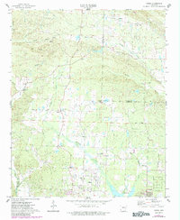
USGS Historical Quadrangle in GeoPDF.
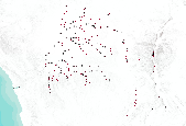
This dataset describes mercury (Hg) stable isotope values in fish dorsal muscle from different freshwater environments across the globe. Fish were collected at numerous field sites in North America, South and Central America, Africa, and Asia from 2006-2020. Sub-samples were provided by cooperators to the U.S. Geological Survey Mercury Research Laboratory and the University of Wisconsin for mercury stable isotope analysis. Samples were analyzed for mercury stable isotopes from 2017-2021. These specimens represent multiple trophic levels and body sizes from different food webs and when adequate mass was available, multiple species from the same food web were examined. Cooperators include, but are not limited to:...
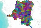
Limites du troisième niveau d’entités administratives de la RDC : territoires (ruraux) et communes (urbaines). Le fichier est issu de la digitalisation par UNOCHA de l’atlas de l’organisation administrative de la RDC réalisé par le père Léon de Saint Moulin. Lorsque les limites de territoires sont définies par un cours d’eau, la géométrie a été partagée. Une validation topologique a été effectuée par UNDP et les limites de communes de Kinshasa ont été ajoutées. L’ensemble des communes de 19 autres villes sont détourées au moyen d’un seul polygone. La toponymie a été validée par l’INS. Boundaries of the third level administrative units of the Democratic Republic of Congo: the rural territories and urban communities....

Afin de garantir la continuité du réseau hydrographique sur les portions navigables, des axes hydrographiques ont été numérisés en 2006 par UNJLC correspondant aux tronçons exploités par la RVF ou la SNCC. Ces axes ont été numérisés à partir du réseau hydrographique transmis par SPIAF. In order to guarantee the hydrographic cover of the navigable portions, the hydrographic axes were enumerated in 2006 by UNJLC, corresponding exploited sections to RVF or SNCC. These axes were enumerated from hydrographic coverages transmitted by SPIAF.
This data set contains imagery from the National Agriculture Imagery Program (NAIP). The NAIP program is administered by USDA FSA and has been established to support two main FSA strategic goals centered on agricultural production. These are, increase stewardship of America's natural resources while enhancing the environment, and to ensure commodities are procured and distributed effectively and efficiently to increase food security. The NAIP program supports these goals by acquiring and providing ortho imagery that has been collected during the agricultural growing season in the U.S. The NAIP ortho imagery is tailored to meet FSA requirements and is a fundamental tool used to support FSA farm and conservation programs....

Les données concernant l’hydrographie sont équivalentes d’une base à l’autre. Les données origine sont issues des fichiers transmis par SPIAF (Inventaire forestier). Pour les cours d’eau linéaire la base originelle était plus détaillée dans les fichiers SPIAF que les fichiers MONUC. C’est donc celle-ci qui a servi de référence. Par la suite la MONUC a transmis une base de meilleure qualité, contenant plus de cours d’eau et d’informations sur les toponymes et le type d’écoulement.Certain tronçons de rivières ont été digitalisé (mise à jour) sur image satellite par UNDP dans les provinces de Kinshasa, du Bas-Congo,du Katanga, Maniema, Nord et Sud-Kivu. The data concerning hydrography are equivalent from one database...
This data release contains the boundaries of assessment units, assessment input data, and resulting fact sheet data tables for the assessment of undiscovered oil and gas resources in the presalt reservoirs of the West-Central Coastal Province of Africa. The Assessment Unit is the fundamental unit used in the National and Global Oil and Gas Assessment Project for the assessment of undiscovered oil and gas resources. The Assessment Unit is defined within the context of the higher-level Total Petroleum System. The Assessment Unit is shown herein as a geographic boundary interpreted, defined, and mapped by the geologist responsible for the province and incorporates a set of known or postulated oil and (or) gas accumulations...
Categories: Data;
Types: Downloadable,
Map Service,
OGC WFS Layer,
OGC WMS Layer,
Shapefile;
Tags: Angola,
Assessment Unit,
Cameroon,
Congo,
Congo Basin Presalt Reservoirs,
This data set contains imagery from the National Agriculture Imagery Program (NAIP). The NAIP program is administered by USDA FSA and has been established to support two main FSA strategic goals centered on agricultural production. These are, increase stewardship of America's natural resources while enhancing the environment, and to ensure commodities are procured and distributed effectively and efficiently to increase food security. The NAIP program supports these goals by acquiring and providing ortho imagery that has been collected during the agricultural growing season in the U.S. The NAIP ortho imagery is tailored to meet FSA requirements and is a fundamental tool used to support FSA farm and conservation programs....

Courbes de niveau avec une équidistance de 100 m. 100 meter contours of the Congo.

Ensemble des tronçons hydrographiques suffisamment large (plus de 200 m de large). Les données concernant l’hydrographie sont équivalentes d’une base à l’autre. Les données origine sont issues des fichiers transmis par SPIAF (Inventaire forestier). Certain tronçons de rivières ont été digitalisé sur image satellite par UNDP dans les provinces de Kinshasa, du Bas-Congo, du Katanga, Maniema, Nord et Sud-Kivu. This is a collection of hydrographic segments longer than 200m. The data concerning hydrography are equivalent from one database to another. These data originate from transmission by SPIAF (Forest Inventory). Certain river segments were digitized by UNDP from satellite images in the province of Kinshasa,...
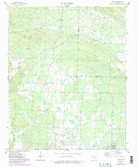
USGS Historical Quadrangle in GeoPDF.
USGS Historical Quadrangle in GeoPDF.
Fish collected for taxonomic and systematic purposes are often preserved and then archived in museum collections. Preserved fish are commonly first fixed in a formalin solution and then transferred to ethanol for long-term storage. The wet preservation method can potentially introduce mercury (Hg) contamination or unintentionally extract Hg from tissue. An experiment was designed to test the utility of museum preserved fishes in reconstructing spatiotemporal trends in methylmercury (MeHg) concentration and Hg stable isotope ratios, which is used to trace Hg sources to fishes. Wet preserved fish specimens from the Congo River and river basins within Gabon were subsampled from archives at the the Royal Museum of Africa...
Categories: Data;
Tags: Congo,
Environmental Health,
Gabon,
Minamata Convention,
USGS Science Data Catalog (SDC),

Le fichier a été généré par agrégation des territoires. Il reprend les limites des districts et des villes de la RDC tel que définit par l’INS. This dataset was generated from an aggregation of territories. It represents the districts and cities of the Democratic Republic of Congo as defined by the INS.
Compilation of Geospatial Data (GIS) for the Mineral Industries and Related Infrastructure of Africa
This geodatabase reflects the U.S. Geological Survey’s (USGS) ongoing commitment to its mission of understanding the nature and distribution of global mineral commodity supply chains by updating and publishing the georeferenced locations of mineral commodity production and processing facilities, mineral exploration and development sites, and mineral commodity exporting ports in Africa. The geodatabase and geospatial data layers serve to create a new geographic information product in the form of a geospatial portable document format (PDF) map. The geodatabase contains data layers from USGS, foreign governmental, and open-source sources as follows: (1) mineral production and processing facilities, (2) mineral exploration...
Bottom simulating reflections (BSRs) are seismic features that are imaged in marine sediments using high-energy, impulsive seismic sources such as air guns or generator-injector guns. BSRs often cut across sediment stratigraphy and are interpreted as marking the deepest depth at which gas hydrate can exist. Gas hydrate is a naturally occurring and widely distributed frozen form of water and gas (usually methane) stable at low temperatures (up to about 25 degrees Celsius [°C]) and intermediate pressures (those that usually correspond to greater than 500 meters water depth). BSRs have been mapped in all the world’s oceans, in inland seas (such as the Black Sea), and in Lake Baikal in Russia. This data release consists...
Categories: Data;
Types: Map Service,
OGC WFS Layer,
OGC WMS Layer,
OGC WMS Service;
Tags: Alaska,
Amazonia,
Antarctica,
Arctic,
Argentina,
|

|
