Filters: Tags: Central America (X)
118 results (95ms)|
Filters
Date Range
Extensions Types Contacts Categories Tag Types Tag Schemes |

Las plantas monocotiledóneas que vuelan de América del Sur, América Central y el Caribe (monocots)

Las Algas (Algae) de América del Sur, América Central y el Caribe .

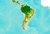
This dataset shows innundation from the terrestrial ecosystems (reference classification) of South America, Central America, and Mexico. South America: This dataset represents Ecological System patches using various reference datasets. Original data generarated from 2000 era data, modeled in 2005 and updated in 2008 and 2010.Originally, this project developed a GIS modeling approach, using a variety of abiotic and biotic data sets, to produce a map of the distribution of Latin America and Caribbean (LAC) ecological systems throughout South America for use in ecoregional assessments. Ecological systems, defined as spatially co-occuring assemblages of vegetation types sharing a common underlying substrate, ecological...

This dataset was extracted from the terrestrial ecosystems of South America dataset. South America: This dataset represents Ecological System patches using various reference datasets. Original data generarated from 2000 era data, modeled in 2005 and updated in 2008 and 2010.Originally, this project developed a GIS modeling approach, using a variety of abiotic and biotic data sets, to produce a map of the distribution of Latin America and Caribbean (LAC) ecological systems throughout South America for use in ecoregional assessments. Ecological systems, defined as spatially co-occuring assemblages of vegetation types sharing a common underlying substrate, ecological process, or gradient, were identified for all...

Las especies invasoras de América del Sur, América Central y el Caribe (invasive species).

The Digital Chart of the World (DCW) is an Environmental Systems Research Institute, Inc. (ESRI) product originally developed for the US Defense Mapping Agency (DMA) using DMA data. The DCW 1993 version at 1:1,000,000 scale was used. The DMA data sources are aeronautical charts, which emphasize landmarks important from flying altitudes. This explains why there is a separate aeronautical theme with all conceivable airports, yet why on some themes small islands and lakes are simply unnamed points. ESRI, in compiling the DCW, also eliminated some detail and made some assumptions for handling tiny polygons and edgematching. Also, note that the completeness of the thematic categories present in each layer will vary....

The Digital Chart of the World (DCW) is an Environmental Systems Research Institute, Inc. (ESRI) product originally developed for the US Defense Mapping Agency (DMA) using DMA data. The DCW 1993 version at 1:1,000,000 scale was used. The DMA data sources are aeronautical charts, which emphasize landmarks important from flying altitudes. This explains why there is a separate aeronautical theme with all conceivable airports, yet why on some themes small islands and lakes are simply unnamed points. ESRI, in compiling the DCW, also eliminated some detail and made some assumptions for handling tiny polygons and edgematching. Also, note that the completeness of the thematic categories present in each layer will vary....
This dataset is an extract from the GlobCover 2009 land cover map, covering Central and South America. The GlobCover 2009 land cover map is derived by an automatic and regionally-tuned classification of a time series of global MERIS (MEdium Resolution Imaging Spectrometer) FR mosaics for the year 2009. The global land cover map counts 22 land cover classes defined with the United Nations (UN) Land Cover Classification System (LCCS). For more information on the GlobCover project, see http://ionia1.esrin.esa.int/ Note on display: class 210: Water Bodies is set to "transparent" to improve display in the Data Basin map. Within the extract's extent, no data were removed from the original dataset.
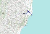
This inventory was originally created by the Ministerio de Medio Ambiente y Recursos Naturales, El Salvador (2001) describing the landslides triggered by the M 7.7 San Miguel, El Salvador earthquake that occurred on 13 January 2001 at 17:33:32 UTC. Care should be taken when comparing with other inventories because different authors use different mapping techniques. This inventory also could be associated with other earthquakes such as aftershocks or triggered events. Please check the author methods summary and the original data source for more information on these details and to confirm the viability of this inventory for your specific use. With the exception of the data from USGS sources, the inventory data and...
Categories: Data;
Types: Citation,
Downloadable,
Map Service,
OGC WFS Layer,
OGC WMS Layer,
Shapefile;
Tags: Central America,
EHP,
Earthquake,
Earthquake Hazards Program,
Earthquakes,
Las especies invasoras de América del Sur, América Central y el Caribe (invasive species).

The Digital Chart of the World (DCW) is an Environmental Systems Research Institute, Inc. (ESRI) product originally developed for the US Defense Mapping Agency (DMA) using DMA data. The DCW 1993 version at 1:1,000,000 scale was used. The DMA data sources are aeronautical charts, which emphasize landmarks important from flying altitudes. This explains why there is a separate aeronautical theme with all conceivable airports, yet why on some themes small islands and lakes are simply unnamed points. ESRI, in compiling the DCW, also eliminated some detail and made some assumptions for handling tiny polygons and edgematching. Also, note that the completeness of the thematic categories present in each layer will vary....

This map presents transportation data, including highways, roads, railroads, and airports for the world. The map was developed by Esri using Esri highway data; DeLorme basemap layers; HERE street data for North America, Europe, Australia, New Zealand, South America and Central America, select countries in Africa, and most of the Middle East. Data from MapmyIndia data in India and OpenStreetMap contributors in select countries in Africa. For more information on this map, including our terms of use, visit us online at http://goto.arcgisonline.com/maps/Reference/World_Transportation
The Digital Chart of the World (DCW) is an Environmental Systems Research Institute, Inc. (ESRI) product originally developed for the US Defense Mapping Agency (DMA) using DMA data. The DCW 1993 version at 1:1,000,000 scale was used. The DMA data sources are aeronautical charts, which emphasize landmarks important from flying altitudes. This explains why there is a separate aeronautical theme with all conceivable airports, yet why on some themes small islands and lakes are simply unnamed points. ESRI, in compiling the DCW, also eliminated some detail and made some assumptions for handling tiny polygons and edgematching. Also, note that the completeness of the thematic categories present in each layer will vary....
Aves de América del Sur, América Central y el Caribe (Birds).

Las Algas (Algae) de América del Sur, América Central y el Caribe .

This dataset was extracted from the terrestrial ecosystems of South America dataset. South America: This dataset represents Ecological System patches using various reference datasets. Original data generarated from 2000 era data, modeled in 2005 and updated in 2008 and 2010.Originally, this project developed a GIS modeling approach, using a variety of abiotic and biotic data sets, to produce a map of the distribution of Latin America and Caribbean (LAC) ecological systems throughout South America for use in ecoregional assessments. Ecological systems, defined as spatially co-occuring assemblages of vegetation types sharing a common underlying substrate, ecological process, or gradient, were identified for all...

10K grid of points indicating cells containing 55-60% cover derived from United Nations FAO www.fao.org/geonetworks/ . These units are defined as units of concern for forest birds.

Pez de América del Sur, América Central y el Caribe (fish)

Los otros Artrópodos de América del Sur, América Central y el Caribe (other arthropods)

Las plantas gimnospermas de América del Sur, América Central y el Caribe l (gymnosperms).
|

|
