Filters
Date Range
Extensions
Types
Contacts
Categories
Tag Types
Tag Schemes
|
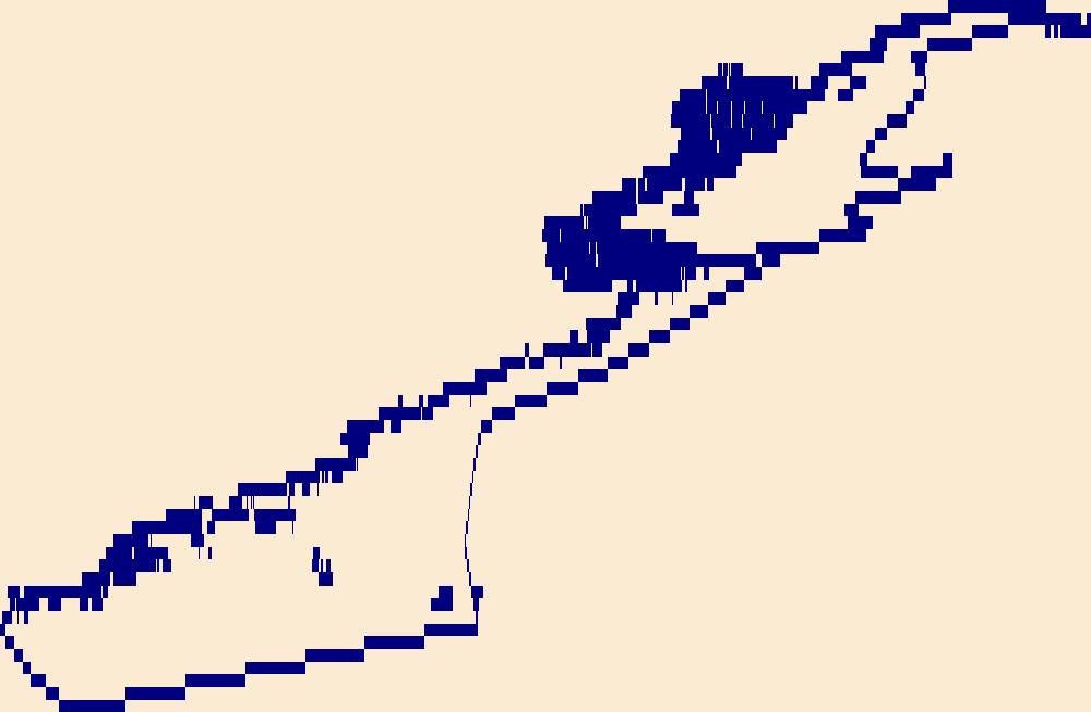
Located in the northern tropical Pacific Ocean, Majuro is the capital of the Republic of the Marshall Islands. Majuro Atoll consists of a large, narrow landmass and a set of smaller perimeter islands surrounding a lagoon that is over 100 square miles in size. The waters surrounding the Majuro Atoll land areas are relatively shallow with poorly mapped bathymetry. However, the Pacific Ocean on the exterior of the coral atoll and the lagoon within its interior consist of deep bathymetry with steep slopes. The highest elevation of the Majuro Atoll is estimated at only 3-meters above sea level, which is the island community of Laura located on the western part of the atoll. At the eastern edge of the atoll lies the capital...
Categories: Data;
Tags: 3D Elevation Program,
3DEP,
American Society of Photogrammetry and Remote Sensing,
Base Maps,
Bathymetric, All tags...
Bathymetry,
Calalin,
Calalin Channel,
CoNED,
Coastal National Elevation Database,
Coastal Zone,
DEM,
DTM,
Digital Elevation Model,
Digital Terrain Model,
Djarrit,
Earth Cover,
Geography,
Geomorphology,
Hydrologic,
Hydrologic Modeling,
Information Sciences,
Laura,
Lidar Bathymetry,
Light Detection and Ranging,
Majuro,
Majuro,
Majuro Atoll,
Majuro Atoll,
Majuro Atoll,
Majuro Atoll,
Multi-beam Sonar,
National Standards for Spatial Digital Accuracy,
Pacific Islands,
Pacific Ocean,
RMI,
Remote Sensing,
Republic of the Marshall Islands,
Rita,
SDB,
Satellite-derived bathymetry,
SfM,
Single-beam Sonar,
Structure from Motion,
TBDEM,
Topobathy,
Topobathymetric,
Topobathymetric Digital Elevation Model,
Topobathymetric Lidar,
U.S.,
U.S. Geological Survey,
USA,
USGS,
USGS Science Data Catalog (SDC),
United States,
Water Resources,
Western Pacific,
Western Pacific Islands,
lidar, Fewer tags
The High Resolution National Hydrography Dataset Plus (NHDPlus HR) is an integrated set of geospatial data layers, including the best available National Hydrography Dataset (NHD), the 10-meter 3D Elevation Program Digital Elevation Model (3DEP DEM), and the National Watershed Boundary Dataset (WBD). The NHDPlus HR combines the NHD, 3DEP DEMs, and WBD to create a stream network with linear referencing, feature naming, "value added attributes" (VAAs), elevation-derived catchments, and other features for hydrologic data analysis. The stream network with linear referencing is a system of data relationships applied to hydrographic systems so that one stream reach "flows" into another and "events" can be tied to and traced...
Tags: Adjuntas County,
Aguada County,
Aguadilla County,
Aguas Buenas County,
Aibonito County, All tags...
Arecibo County,
Arroyo County,
Añasco County,
Barceloneta County,
Barranquitas County,
Bayamón County,
Cabo Rojo County,
Caguas County,
Camuy County,
Canóvanas County,
Carolina County,
Cataño County,
Cayey County,
Ceiba County,
Ciales County,
Cidra County,
Coamo County,
Comerío County,
Corozal County,
Culebra County,
Dorado County,
Downloadable Data,
Fajardo County,
FileGDB,
FileGDB 10.1,
Florida County,
Guayama County,
Guayanilla County,
Guaynabo County,
Gurabo County,
Guánica County,
HU-4 Subregion,
HU-4 Subregion,
HU4_2101,
Hatillo County,
Hormigueros County,
Humacao County,
Hydrography,
Isabela County,
Jayuya County,
Juana Díaz County,
Juncos County,
Lajas County,
Lares County,
Las Marías County,
Las Piedras County,
Loíza County,
Luquillo County,
Manatí County,
Maricao County,
Maunabo County,
Mayagüez County,
Moca County,
Morovis County,
NHDPlus HR Rasters,
NHDPlus High Resolution (NHDPlus HR),
Naguabo County,
Naranjito County,
National Hydrography Dataset (NHD),
National Hydrography Dataset Plus High Resolution (NHDPlus HR),
National Hydrography Dataset Plus High Resolution (NHDPlus HR) Current,
Orocovis County,
PR,
Patillas County,
Peñuelas County,
Ponce County,
Puerto Rico,
Quebradillas County,
Rincón County,
Río Grande County,
Sabana Grande County,
Salinas County,
San Germán County,
San Juan County,
San Lorenzo County,
San Sebastián County,
Santa Isabel County,
Toa Alta County,
Toa Baja County,
Trujillo Alto County,
US,
United States,
Utuado County,
Vega Alta County,
Vega Baja County,
Vieques County,
Villalba County,
Yabucoa County,
Yauco County,
base maps,
cartography,
catchments,
channels,
digital elevation models,
drainage basins,
earth sciences,
elevation,
environment,
geographic information systems,
geoscientific,
geospatial analysis,
hydrographic datasets,
hydrographic features,
hydrology,
imagery,
inland waters,
lakes,
land surface characteristics,
reservoirs,
river reaches,
rivers,
streamflow,
streamflow data,
streams,
topography,
water bodies,
water quality,
water resources,
watersheds, Fewer tags
The High Resolution National Hydrography Dataset Plus (NHDPlus HR) is an integrated set of geospatial data layers, including the best available National Hydrography Dataset (NHD), the 10-meter 3D Elevation Program Digital Elevation Model (3DEP DEM), and the National Watershed Boundary Dataset (WBD). The NHDPlus HR combines the NHD, 3DEP DEMs, and WBD to create a stream network with linear referencing, feature naming, "value added attributes" (VAAs), elevation-derived catchments, and other features for hydrologic data analysis. The stream network with linear referencing is a system of data relationships applied to hydrographic systems so that one stream reach "flows" into another and "events" can be tied to and traced...
Tags: AuroraCounty,
BeadleCounty,
BennettCounty,
BoydCounty,
BruleCounty, All tags...
BuffaloCounty,
Charles MixCounty,
CherryCounty,
DawesCounty,
DouglasCounty,
Downloadable Data,
Fall RiverCounty,
FaulkCounty,
FileGDB,
FileGDB 10.1,
GregoryCounty,
HU-4 Subregion,
HU-4 Subregion,
HU4_1014,
HaakonCounty,
HandCounty,
HughesCounty,
HydeCounty,
Hydrography,
JacksonCounty,
JerauldCounty,
JonesCounty,
LymanCounty,
MelletteCounty,
NHDPlus HR Rasters,
NHDPlus High Resolution (NHDPlus HR),
National Hydrography Dataset (NHD),
National Hydrography Dataset Plus High Resolution (NHDPlus HR),
National Hydrography Dataset Plus High Resolution (NHDPlus HR) Current,
Oglala LakotaCounty,
PenningtonCounty,
PotterCounty,
SD,
SheridanCounty,
SiouxCounty,
South Dakota,
StanleyCounty,
SullyCounty,
ToddCounty,
TrippCounty,
US,
United States,
base maps,
cartography,
catchments,
channels,
digital elevation models,
drainage basins,
earth sciences,
elevation,
environment,
geographic information systems,
geoscientific,
geospatial analysis,
hydrographic datasets,
hydrographic features,
hydrology,
imagery,
inland waters,
lakes,
land surface characteristics,
reservoirs,
river reaches,
rivers,
streamflow,
streamflow data,
streams,
topography,
water bodies,
water quality,
water resources,
watersheds, Fewer tags
The High Resolution National Hydrography Dataset Plus (NHDPlus HR) is an integrated set of geospatial data layers, including the best available National Hydrography Dataset (NHD), the 10-meter 3D Elevation Program Digital Elevation Model (3DEP DEM), and the National Watershed Boundary Dataset (WBD). The NHDPlus HR combines the NHD, 3DEP DEMs, and WBD to create a stream network with linear referencing, feature naming, "value added attributes" (VAAs), elevation-derived catchments, and other features for hydrologic data analysis. The stream network with linear referencing is a system of data relationships applied to hydrographic systems so that one stream reach "flows" into another and "events" can be tied to and traced...
Tags: AK,
Alaska,
Anchorage County,
Downloadable Data,
FileGDB, All tags...
FileGDB 10.1,
HU-8 Subbasin,
HU-8 Subbasin,
HU8_19020401,
Hydrography,
Kenai Peninsula County,
Matanuska-Susitna County,
NHDPlus HR Rasters,
NHDPlus High Resolution (NHDPlus HR),
National Hydrography Dataset (NHD),
National Hydrography Dataset Plus High Resolution (NHDPlus HR),
National Hydrography Dataset Plus High Resolution (NHDPlus HR) Current,
US,
United States,
base maps,
cartography,
catchments,
channels,
digital elevation models,
drainage basins,
earth sciences,
elevation,
environment,
geographic information systems,
geoscientific,
geospatial analysis,
hydrographic datasets,
hydrographic features,
hydrology,
imagery,
inland waters,
lakes,
land surface characteristics,
reservoirs,
river reaches,
rivers,
streamflow,
streamflow data,
streams,
topography,
water bodies,
water quality,
water resources,
watersheds, Fewer tags
The High Resolution National Hydrography Dataset Plus (NHDPlus HR) is an integrated set of geospatial data layers, including the best available National Hydrography Dataset (NHD), the 10-meter 3D Elevation Program Digital Elevation Model (3DEP DEM), and the National Watershed Boundary Dataset (WBD). The NHDPlus HR combines the NHD, 3DEP DEMs, and WBD to create a stream network with linear referencing, feature naming, "value added attributes" (VAAs), elevation-derived catchments, and other features for hydrologic data analysis. The stream network with linear referencing is a system of data relationships applied to hydrographic systems so that one stream reach "flows" into another and "events" can be tied to and traced...
Tags: Allegany County,
Cattaraugus County,
Downloadable Data,
FileGDB,
FileGDB 10.1, All tags...
Genesee County,
HU-4 Subregion,
HU-4 Subregion,
HU4_0413,
Hydrography,
Livingston County,
Monroe County,
NHDPlus HR Rasters,
NHDPlus High Resolution (NHDPlus HR),
NY,
National Hydrography Dataset (NHD),
National Hydrography Dataset Plus High Resolution (NHDPlus HR),
National Hydrography Dataset Plus High Resolution (NHDPlus HR) Current,
New York,
Niagara County,
Ontario County,
Orleans County,
PA,
Pennsylvania,
Potter County,
Steuben County,
US,
United States,
Wyoming County,
base maps,
cartography,
catchments,
channels,
digital elevation models,
drainage basins,
earth sciences,
elevation,
environment,
geographic information systems,
geoscientific,
geospatial analysis,
hydrographic datasets,
hydrographic features,
hydrology,
imagery,
inland waters,
lakes,
land surface characteristics,
reservoirs,
river reaches,
rivers,
streamflow,
streamflow data,
streams,
topography,
water bodies,
water quality,
water resources,
watersheds, Fewer tags
The High Resolution National Hydrography Dataset Plus (NHDPlus HR) is an integrated set of geospatial data layers, including the best available National Hydrography Dataset (NHD), the 10-meter 3D Elevation Program Digital Elevation Model (3DEP DEM), and the National Watershed Boundary Dataset (WBD). The NHDPlus HR combines the NHD, 3DEP DEMs, and WBD to create a stream network with linear referencing, feature naming, "value added attributes" (VAAs), elevation-derived catchments, and other features for hydrologic data analysis. The stream network with linear referencing is a system of data relationships applied to hydrographic systems so that one stream reach "flows" into another and "events" can be tied to and traced...
Tags: Belknap County,
Carroll County,
Cheshire County,
Downloadable Data,
Essex County, All tags...
FileGDB,
FileGDB 10.1,
Grafton County,
HU-4 Subregion,
HU-4 Subregion,
HU4_0107,
Hillsborough County,
Hydrography,
MA,
Massachusetts,
Merrimack County,
Middlesex County,
NH,
NHDPlus HR Rasters,
NHDPlus High Resolution (NHDPlus HR),
National Hydrography Dataset (NHD),
National Hydrography Dataset Plus High Resolution (NHDPlus HR),
National Hydrography Dataset Plus High Resolution (NHDPlus HR) Current,
New Hampshire,
Rockingham County,
Strafford County,
Sullivan County,
US,
United States,
Worcester County,
base maps,
cartography,
catchments,
channels,
digital elevation models,
drainage basins,
earth sciences,
elevation,
environment,
geographic information systems,
geoscientific,
geospatial analysis,
hydrographic datasets,
hydrographic features,
hydrology,
imagery,
inland waters,
lakes,
land surface characteristics,
reservoirs,
river reaches,
rivers,
streamflow,
streamflow data,
streams,
topography,
water bodies,
water quality,
water resources,
watersheds, Fewer tags
The High Resolution National Hydrography Dataset Plus (NHDPlus HR) is an integrated set of geospatial data layers, including the best available National Hydrography Dataset (NHD), the 10-meter 3D Elevation Program Digital Elevation Model (3DEP DEM), and the National Watershed Boundary Dataset (WBD). The NHDPlus HR combines the NHD, 3DEP DEMs, and WBD to create a stream network with linear referencing, feature naming, "value added attributes" (VAAs), elevation-derived catchments, and other features for hydrologic data analysis. The stream network with linear referencing is a system of data relationships applied to hydrographic systems so that one stream reach "flows" into another and "events" can be tied to and traced...
Tags: AddisonCounty,
BenningtonCounty,
BerkshireCounty,
CaledoniaCounty,
CarrollCounty, All tags...
CheshireCounty,
CoosCounty,
Downloadable Data,
EssexCounty,
FileGDB,
FileGDB 10.1,
FranklinCounty,
GraftonCounty,
HU-4 Subregion,
HU-4 Subregion,
HU4_0108,
HampdenCounty,
HampshireCounty,
HartfordCounty,
HillsboroughCounty,
Hydrography,
LitchfieldCounty,
ME,
Maine,
MerrimackCounty,
MiddlesexCounty,
MiddlesexCounty,
NHDPlus HR Rasters,
NHDPlus High Resolution (NHDPlus HR),
National Hydrography Dataset (NHD),
National Hydrography Dataset Plus High Resolution (NHDPlus HR),
National Hydrography Dataset Plus High Resolution (NHDPlus HR) Current,
New HavenCounty,
New LondonCounty,
OrangeCounty,
OrleansCounty,
OxfordCounty,
RutlandCounty,
SullivanCounty,
TollandCounty,
US,
United States,
WashingtonCounty,
WindhamCounty,
WindsorCounty,
WorcesterCounty,
base maps,
cartography,
catchments,
channels,
digital elevation models,
drainage basins,
earth sciences,
elevation,
environment,
geographic information systems,
geoscientific,
geospatial analysis,
hydrographic datasets,
hydrographic features,
hydrology,
imagery,
inland waters,
lakes,
land surface characteristics,
reservoirs,
river reaches,
rivers,
streamflow,
streamflow data,
streams,
topography,
water bodies,
water quality,
water resources,
watersheds, Fewer tags
The High Resolution National Hydrography Dataset Plus (NHDPlus HR) is an integrated set of geospatial data layers, including the best available National Hydrography Dataset (NHD), the 10-meter 3D Elevation Program Digital Elevation Model (3DEP DEM), and the National Watershed Boundary Dataset (WBD). The NHDPlus HR combines the NHD, 3DEP DEMs, and WBD to create a stream network with linear referencing, feature naming, "value added attributes" (VAAs), elevation-derived catchments, and other features for hydrologic data analysis. The stream network with linear referencing is a system of data relationships applied to hydrographic systems so that one stream reach "flows" into another and "events" can be tied to and traced...
Tags: CharlotteCounty,
CitrusCounty,
DeSotoCounty,
Downloadable Data,
FL, All tags...
FileGDB,
FileGDB 10.1,
Florida,
GladesCounty,
HU-4 Subregion,
HU-4 Subregion,
HU4_0310,
HardeeCounty,
HernandoCounty,
HighlandsCounty,
HillsboroughCounty,
Hydrography,
LakeCounty,
LeeCounty,
LevyCounty,
ManateeCounty,
MarionCounty,
NHDPlus HR Rasters,
NHDPlus High Resolution (NHDPlus HR),
National Hydrography Dataset (NHD),
National Hydrography Dataset Plus High Resolution (NHDPlus HR),
National Hydrography Dataset Plus High Resolution (NHDPlus HR) Current,
PascoCounty,
PinellasCounty,
PolkCounty,
SarasotaCounty,
SumterCounty,
US,
United States,
base maps,
cartography,
catchments,
channels,
digital elevation models,
drainage basins,
earth sciences,
elevation,
environment,
geographic information systems,
geoscientific,
geospatial analysis,
hydrographic datasets,
hydrographic features,
hydrology,
imagery,
inland waters,
lakes,
land surface characteristics,
reservoirs,
river reaches,
rivers,
streamflow,
streamflow data,
streams,
topography,
water bodies,
water quality,
water resources,
watersheds, Fewer tags
The High Resolution National Hydrography Dataset Plus (NHDPlus HR) is an integrated set of geospatial data layers, including the best available National Hydrography Dataset (NHD), the 10-meter 3D Elevation Program Digital Elevation Model (3DEP DEM), and the National Watershed Boundary Dataset (WBD). The NHDPlus HR combines the NHD, 3DEP DEMs, and WBD to create a stream network with linear referencing, feature naming, "value added attributes" (VAAs), elevation-derived catchments, and other features for hydrologic data analysis. The stream network with linear referencing is a system of data relationships applied to hydrographic systems so that one stream reach "flows" into another and "events" can be tied to and traced...
Tags: BlaineCounty,
ChouteauCounty,
Downloadable Data,
FileGDB,
FileGDB 10.1, All tags...
GlacierCounty,
HU-4 Subregion,
HU-4 Subregion,
HU4_1005,
HillCounty,
Hydrography,
LibertyCounty,
MT,
Montana,
NHDPlus HR Rasters,
NHDPlus High Resolution (NHDPlus HR),
National Hydrography Dataset (NHD),
National Hydrography Dataset Plus High Resolution (NHDPlus HR),
National Hydrography Dataset Plus High Resolution (NHDPlus HR) Current,
PhillipsCounty,
TooleCounty,
US,
United States,
ValleyCounty,
base maps,
cartography,
catchments,
channels,
digital elevation models,
drainage basins,
earth sciences,
elevation,
environment,
geographic information systems,
geoscientific,
geospatial analysis,
hydrographic datasets,
hydrographic features,
hydrology,
imagery,
inland waters,
lakes,
land surface characteristics,
reservoirs,
river reaches,
rivers,
streamflow,
streamflow data,
streams,
topography,
water bodies,
water quality,
water resources,
watersheds, Fewer tags
The High Resolution National Hydrography Dataset Plus (NHDPlus HR) is an integrated set of geospatial data layers, including the best available National Hydrography Dataset (NHD), the 10-meter 3D Elevation Program Digital Elevation Model (3DEP DEM), and the National Watershed Boundary Dataset (WBD). The NHDPlus HR combines the NHD, 3DEP DEMs, and WBD to create a stream network with linear referencing, feature naming, "value added attributes" (VAAs), elevation-derived catchments, and other features for hydrologic data analysis. The stream network with linear referencing is a system of data relationships applied to hydrographic systems so that one stream reach "flows" into another and "events" can be tied to and traced...
Tags: AdamsCounty,
AlbanyCounty,
ArapahoeCounty,
BannerCounty,
BoulderCounty, All tags...
BroomfieldCounty,
ChaffeeCounty,
CheyenneCounty,
Clear CreekCounty,
DenverCounty,
DeuelCounty,
DouglasCounty,
Downloadable Data,
El PasoCounty,
ElbertCounty,
FileGDB,
FileGDB 10.1,
GardenCounty,
GilpinCounty,
GrandCounty,
HU-4 Subregion,
HU-4 Subregion,
HU4_1019,
Hydrography,
JacksonCounty,
JeffersonCounty,
KeithCounty,
KimballCounty,
LakeCounty,
LaramieCounty,
LarimerCounty,
LincolnCounty,
LincolnCounty,
LoganCounty,
MorganCounty,
NE,
NHDPlus HR Rasters,
NHDPlus High Resolution (NHDPlus HR),
National Hydrography Dataset (NHD),
National Hydrography Dataset Plus High Resolution (NHDPlus HR),
National Hydrography Dataset Plus High Resolution (NHDPlus HR) Current,
Nebraska,
ParkCounty,
PerkinsCounty,
SedgwickCounty,
SummitCounty,
TellerCounty,
US,
United States,
WashingtonCounty,
WeldCounty,
base maps,
cartography,
catchments,
channels,
digital elevation models,
drainage basins,
earth sciences,
elevation,
environment,
geographic information systems,
geoscientific,
geospatial analysis,
hydrographic datasets,
hydrographic features,
hydrology,
imagery,
inland waters,
lakes,
land surface characteristics,
reservoirs,
river reaches,
rivers,
streamflow,
streamflow data,
streams,
topography,
water bodies,
water quality,
water resources,
watersheds, Fewer tags
The High Resolution National Hydrography Dataset Plus (NHDPlus HR) is an integrated set of geospatial data layers, including the best available National Hydrography Dataset (NHD), the 10-meter 3D Elevation Program Digital Elevation Model (3DEP DEM), and the National Watershed Boundary Dataset (WBD). The NHDPlus HR combines the NHD, 3DEP DEMs, and WBD to create a stream network with linear referencing, feature naming, "value added attributes" (VAAs), elevation-derived catchments, and other features for hydrologic data analysis. The stream network with linear referencing is a system of data relationships applied to hydrographic systems so that one stream reach "flows" into another and "events" can be tied to and traced...
Tags: AdamsCounty,
AntelopeCounty,
BooneCounty,
BuffaloCounty,
ButlerCounty, All tags...
CassCounty,
ColfaxCounty,
CusterCounty,
DawsonCounty,
DodgeCounty,
DouglasCounty,
Downloadable Data,
FileGDB,
FileGDB 10.1,
FrontierCounty,
GageCounty,
GosperCounty,
HU-4 Subregion,
HU-4 Subregion,
HU4_1020,
HallCounty,
HamiltonCounty,
HowardCounty,
Hydrography,
KearneyCounty,
LancasterCounty,
LincolnCounty,
LoganCounty,
MadisonCounty,
McPhersonCounty,
MerrickCounty,
NE,
NHDPlus HR Rasters,
NHDPlus High Resolution (NHDPlus HR),
NanceCounty,
National Hydrography Dataset (NHD),
National Hydrography Dataset Plus High Resolution (NHDPlus HR),
National Hydrography Dataset Plus High Resolution (NHDPlus HR) Current,
Nebraska,
PhelpsCounty,
PlatteCounty,
PolkCounty,
SalineCounty,
SarpyCounty,
SaundersCounty,
SewardCounty,
US,
United States,
base maps,
cartography,
catchments,
channels,
digital elevation models,
drainage basins,
earth sciences,
elevation,
environment,
geographic information systems,
geoscientific,
geospatial analysis,
hydrographic datasets,
hydrographic features,
hydrology,
imagery,
inland waters,
lakes,
land surface characteristics,
reservoirs,
river reaches,
rivers,
streamflow,
streamflow data,
streams,
topography,
water bodies,
water quality,
water resources,
watersheds, Fewer tags
The High Resolution National Hydrography Dataset Plus (NHDPlus HR) is an integrated set of geospatial data layers, including the best available National Hydrography Dataset (NHD), the 10-meter 3D Elevation Program Digital Elevation Model (3DEP DEM), and the National Watershed Boundary Dataset (WBD). The NHDPlus HR combines the NHD, 3DEP DEMs, and WBD to create a stream network with linear referencing, feature naming, "value added attributes" (VAAs), elevation-derived catchments, and other features for hydrologic data analysis. The stream network with linear referencing is a system of data relationships applied to hydrographic systems so that one stream reach "flows" into another and "events" can be tied to and traced...
Tags: Archer County,
Baylor County,
Beckham County,
Briscoe County,
Bryan County, All tags...
Caddo County,
Canadian County,
Carter County,
Childress County,
Clay County,
Collingsworth County,
Comanche County,
Cooke County,
Cottle County,
Cotton County,
Crosby County,
Custer County,
Dewey County,
Dickens County,
Downloadable Data,
FileGDB,
FileGDB 10.1,
Floyd County,
Foard County,
Garvin County,
Grady County,
Gray County,
Grayson County,
HU-4 Subregion,
HU-4 Subregion,
HU4_1113,
Hale County,
Hall County,
Hardeman County,
Harmon County,
Hemphill County,
Hydrography,
Jackson County,
Jefferson County,
Johnston County,
King County,
Kiowa County,
Knox County,
Love County,
Marshall County,
McClain County,
Montague County,
Motley County,
Murray County,
NHDPlus HR Rasters,
NHDPlus High Resolution (NHDPlus HR),
National Hydrography Dataset (NHD),
National Hydrography Dataset Plus High Resolution (NHDPlus HR),
National Hydrography Dataset Plus High Resolution (NHDPlus HR) Current,
OK,
Oklahoma,
Pontotoc County,
Roberts County,
Roger Mills County,
Stephens County,
Swisher County,
TX,
Texas,
Tillman County,
US,
United States,
Washita County,
Wheeler County,
Wichita County,
Wilbarger County,
Young County,
base maps,
cartography,
catchments,
channels,
digital elevation models,
drainage basins,
earth sciences,
elevation,
environment,
geographic information systems,
geoscientific,
geospatial analysis,
hydrographic datasets,
hydrographic features,
hydrology,
imagery,
inland waters,
lakes,
land surface characteristics,
reservoirs,
river reaches,
rivers,
streamflow,
streamflow data,
streams,
topography,
water bodies,
water quality,
water resources,
watersheds, Fewer tags
The High Resolution National Hydrography Dataset Plus (NHDPlus HR) is an integrated set of geospatial data layers, including the best available National Hydrography Dataset (NHD), the 10-meter 3D Elevation Program Digital Elevation Model (3DEP DEM), and the National Watershed Boundary Dataset (WBD). The NHDPlus HR combines the NHD, 3DEP DEMs, and WBD to create a stream network with linear referencing, feature naming, "value added attributes" (VAAs), elevation-derived catchments, and other features for hydrologic data analysis. The stream network with linear referencing is a system of data relationships applied to hydrographic systems so that one stream reach "flows" into another and "events" can be tied to and traced...
Tags: Chaves County,
Culberson County,
Curry County,
De Baca County,
Downloadable Data, All tags...
Eddy County,
FileGDB,
FileGDB 10.1,
Guadalupe County,
HU-4 Subregion,
HU-4 Subregion,
HU4_1306,
Hydrography,
Lea County,
Lincoln County,
Mora County,
NHDPlus HR Rasters,
NHDPlus High Resolution (NHDPlus HR),
NM,
National Hydrography Dataset (NHD),
National Hydrography Dataset Plus High Resolution (NHDPlus HR),
National Hydrography Dataset Plus High Resolution (NHDPlus HR) Current,
New Mexico,
Otero County,
Quay County,
Rio Arriba County,
Roosevelt County,
San Miguel County,
Santa Fe County,
TX,
Texas,
Torrance County,
US,
United States,
base maps,
cartography,
catchments,
channels,
digital elevation models,
drainage basins,
earth sciences,
elevation,
environment,
geographic information systems,
geoscientific,
geospatial analysis,
hydrographic datasets,
hydrographic features,
hydrology,
imagery,
inland waters,
lakes,
land surface characteristics,
reservoirs,
river reaches,
rivers,
streamflow,
streamflow data,
streams,
topography,
water bodies,
water quality,
water resources,
watersheds, Fewer tags
The High Resolution National Hydrography Dataset Plus (NHDPlus HR) is an integrated set of geospatial data layers, including the best available National Hydrography Dataset (NHD), the 10-meter 3D Elevation Program Digital Elevation Model (3DEP DEM), and the National Watershed Boundary Dataset (WBD). The NHDPlus HR combines the NHD, 3DEP DEMs, and WBD to create a stream network with linear referencing, feature naming, "value added attributes" (VAAs), elevation-derived catchments, and other features for hydrologic data analysis. The stream network with linear referencing is a system of data relationships applied to hydrographic systems so that one stream reach "flows" into another and "events" can be tied to and traced...
Tags: Adams County,
Benton County,
Chelan County,
Douglas County,
Downloadable Data, All tags...
Ferry County,
FileGDB,
FileGDB 10.1,
Franklin County,
Grant County,
HU-4 Subregion,
HU-4 Subregion,
HU4_1702,
Hydrography,
King County,
Kittitas County,
Lincoln County,
NHDPlus HR Rasters,
NHDPlus High Resolution (NHDPlus HR),
National Hydrography Dataset (NHD),
National Hydrography Dataset Plus High Resolution (NHDPlus HR),
National Hydrography Dataset Plus High Resolution (NHDPlus HR) Current,
Okanogan County,
Pend Oreille County,
Skagit County,
Snohomish County,
Spokane County,
Stevens County,
US,
United States,
WA,
Walla Walla County,
Washington,
Whatcom County,
Yakima County,
base maps,
cartography,
catchments,
channels,
digital elevation models,
drainage basins,
earth sciences,
elevation,
environment,
geographic information systems,
geoscientific,
geospatial analysis,
hydrographic datasets,
hydrographic features,
hydrology,
imagery,
inland waters,
lakes,
land surface characteristics,
reservoirs,
river reaches,
rivers,
streamflow,
streamflow data,
streams,
topography,
water bodies,
water quality,
water resources,
watersheds, Fewer tags
Disclaimer: this is an historic version of NLCD provided for research and citation purposes. Different release dates of NLCD cannot be used with other release dates for correct analysis. Each release of NLCD generates a complete set of directly comparable products. These products must be used together for correct analysis. You can find the latest suite of synced products at www.mrlc.gov. The National Land Cover Database 2001 land cover layer for mapping zones 01-66 was produced through a cooperative project conducted by the Multi-Resolution Land Characteristics (MRLC) Consortium. The MRLC Consortium is a partnership of federal agencies (www.mrlc.gov), consisting of the U.S. Geological Survey (USGS), the National...
Types: Map Service,
OGC WFS Layer,
OGC WMS Layer,
OGC WMS Service;
Tags: Base Maps,
Coastal Zone,
Earth Cover,
GIS,
Land Cover, All tags...
Land Use Change,
U.S.,
U.S. Geological Survey,
US,
US West Coast,
USGS,
USGS Science Data Catalog (SDC),
United States,
WA,
Washington,
digital spatial data,
imagery,
zone 01, Fewer tags
The High Resolution National Hydrography Dataset Plus (NHDPlus HR) is an integrated set of geospatial data layers, including the best available National Hydrography Dataset (NHD), the 10-meter 3D Elevation Program Digital Elevation Model (3DEP DEM), and the National Watershed Boundary Dataset (WBD). The NHDPlus HR combines the NHD, 3DEP DEMs, and WBD to create a stream network with linear referencing, feature naming, "value added attributes" (VAAs), elevation-derived catchments, and other features for hydrologic data analysis. The stream network with linear referencing is a system of data relationships applied to hydrographic systems so that one stream reach "flows" into another and "events" can be tied to and traced...
Tags: Aitkin County,
Ashland County,
Bayfield County,
Carlton County,
Cook County, All tags...
Douglas County,
Downloadable Data,
FileGDB,
FileGDB 10.1,
Gogebic County,
HU-4 Subregion,
HU-4 Subregion,
HU4_0401,
Hydrography,
Iron County,
Itasca County,
Lake County,
MI,
MN,
Michigan,
Minnesota,
NHDPlus HR Rasters,
NHDPlus High Resolution (NHDPlus HR),
National Hydrography Dataset (NHD),
National Hydrography Dataset Plus High Resolution (NHDPlus HR),
National Hydrography Dataset Plus High Resolution (NHDPlus HR) Current,
Pine County,
St. Louis County,
US,
United States,
WI,
Wisconsin,
base maps,
cartography,
catchments,
channels,
digital elevation models,
drainage basins,
earth sciences,
elevation,
environment,
geographic information systems,
geoscientific,
geospatial analysis,
hydrographic datasets,
hydrographic features,
hydrology,
imagery,
inland waters,
lakes,
land surface characteristics,
reservoirs,
river reaches,
rivers,
streamflow,
streamflow data,
streams,
topography,
water bodies,
water quality,
water resources,
watersheds, Fewer tags
The High Resolution National Hydrography Dataset Plus (NHDPlus HR) is an integrated set of geospatial data layers, including the best available National Hydrography Dataset (NHD), the 10-meter 3D Elevation Program Digital Elevation Model (3DEP DEM), and the National Watershed Boundary Dataset (WBD). The NHDPlus HR combines the NHD, 3DEP DEMs, and WBD to create a stream network with linear referencing, feature naming, "value added attributes" (VAAs), elevation-derived catchments, and other features for hydrologic data analysis. The stream network with linear referencing is a system of data relationships applied to hydrographic systems so that one stream reach "flows" into another and "events" can be tied to and traced...
Tags: Alcona County,
Alpena County,
Arenac County,
Bay County,
Cheboygan County, All tags...
Chippewa County,
Downloadable Data,
Emmet County,
FileGDB,
FileGDB 10.1,
HU-4 Subregion,
HU-4 Subregion,
HU4_0424,
Huron County,
Hydrography,
Iosco County,
MI,
Mackinac County,
Michigan,
NHDPlus HR Rasters,
NHDPlus High Resolution (NHDPlus HR),
National Hydrography Dataset (NHD),
National Hydrography Dataset Plus High Resolution (NHDPlus HR),
National Hydrography Dataset Plus High Resolution (NHDPlus HR) Current,
Presque Isle County,
Sanilac County,
St. Clair County,
Tuscola County,
US,
United States,
base maps,
cartography,
catchments,
channels,
digital elevation models,
drainage basins,
earth sciences,
elevation,
environment,
geographic information systems,
geoscientific,
geospatial analysis,
hydrographic datasets,
hydrographic features,
hydrology,
imagery,
inland waters,
lakes,
land surface characteristics,
reservoirs,
river reaches,
rivers,
streamflow,
streamflow data,
streams,
topography,
water bodies,
water quality,
water resources,
watersheds, Fewer tags
The High Resolution National Hydrography Dataset Plus (NHDPlus HR) is an integrated set of geospatial data layers, including the best available National Hydrography Dataset (NHD), the 10-meter 3D Elevation Program Digital Elevation Model (3DEP DEM), and the National Watershed Boundary Dataset (WBD). The NHDPlus HR combines the NHD, 3DEP DEMs, and WBD to create a stream network with linear referencing, feature naming, "value added attributes" (VAAs), elevation-derived catchments, and other features for hydrologic data analysis. The stream network with linear referencing is a system of data relationships applied to hydrographic systems so that one stream reach "flows" into another and "events" can be tied to and traced...
Tags: Ashtabula County,
Chautauqua County,
Cuyahoga County,
Downloadable Data,
Erie County, All tags...
Erie County,
Erie County,
FileGDB,
FileGDB 10.1,
HU-4 Subregion,
HU-4 Subregion,
HU4_0426i,
Hydrography,
Lake County,
Lorain County,
Lucas County,
MI,
Michigan,
Monroe County,
NHDPlus HR Rasters,
NHDPlus High Resolution (NHDPlus HR),
NY,
National Hydrography Dataset (NHD),
National Hydrography Dataset Plus High Resolution (NHDPlus HR),
National Hydrography Dataset Plus High Resolution (NHDPlus HR) Current,
New York,
OH,
Ohio,
Ottawa County,
PA,
Pennsylvania,
Sandusky County,
US,
United States,
Wayne County,
base maps,
cartography,
catchments,
channels,
digital elevation models,
drainage basins,
earth sciences,
elevation,
environment,
geographic information systems,
geoscientific,
geospatial analysis,
hydrographic datasets,
hydrographic features,
hydrology,
imagery,
inland waters,
lakes,
land surface characteristics,
reservoirs,
river reaches,
rivers,
streamflow,
streamflow data,
streams,
topography,
water bodies,
water quality,
water resources,
watersheds, Fewer tags
The High Resolution National Hydrography Dataset Plus (NHDPlus HR) is an integrated set of geospatial data layers, including the best available National Hydrography Dataset (NHD), the 10-meter 3D Elevation Program Digital Elevation Model (3DEP DEM), and the National Watershed Boundary Dataset (WBD). The NHDPlus HR combines the NHD, 3DEP DEMs, and WBD to create a stream network with linear referencing, feature naming, "value added attributes" (VAAs), elevation-derived catchments, and other features for hydrologic data analysis. The stream network with linear referencing is a system of data relationships applied to hydrographic systems so that one stream reach "flows" into another and "events" can be tied to and traced...
Tags: BeaufortCounty,
BrunswickCounty,
CarteretCounty,
CravenCounty,
DareCounty, All tags...
Downloadable Data,
DuplinCounty,
DurhamCounty,
EdgecombeCounty,
FileGDB,
FileGDB 10.1,
FranklinCounty,
GranvilleCounty,
GreeneCounty,
HU-4 Subregion,
HU-4 Subregion,
HU4_0302,
HalifaxCounty,
HarnettCounty,
HydeCounty,
Hydrography,
JohnstonCounty,
JonesCounty,
LenoirCounty,
MartinCounty,
NC,
NHDPlus HR Rasters,
NHDPlus High Resolution (NHDPlus HR),
NashCounty,
National Hydrography Dataset (NHD),
National Hydrography Dataset Plus High Resolution (NHDPlus HR),
National Hydrography Dataset Plus High Resolution (NHDPlus HR) Current,
New HanoverCounty,
North Carolina,
OnslowCounty,
OrangeCounty,
PamlicoCounty,
PenderCounty,
PersonCounty,
PittCounty,
SampsonCounty,
TyrrellCounty,
US,
United States,
VanceCounty,
WakeCounty,
WarrenCounty,
WashingtonCounty,
WayneCounty,
WilsonCounty,
base maps,
cartography,
catchments,
channels,
digital elevation models,
drainage basins,
earth sciences,
elevation,
environment,
geographic information systems,
geoscientific,
geospatial analysis,
hydrographic datasets,
hydrographic features,
hydrology,
imagery,
inland waters,
lakes,
land surface characteristics,
reservoirs,
river reaches,
rivers,
streamflow,
streamflow data,
streams,
topography,
water bodies,
water quality,
water resources,
watersheds, Fewer tags
The High Resolution National Hydrography Dataset Plus (NHDPlus HR) is an integrated set of geospatial data layers, including the best available National Hydrography Dataset (NHD), the 10-meter 3D Elevation Program Digital Elevation Model (3DEP DEM), and the National Watershed Boundary Dataset (WBD). The NHDPlus HR combines the NHD, 3DEP DEMs, and WBD to create a stream network with linear referencing, feature naming, "value added attributes" (VAAs), elevation-derived catchments, and other features for hydrologic data analysis. The stream network with linear referencing is a system of data relationships applied to hydrographic systems so that one stream reach "flows" into another and "events" can be tied to and traced...
Tags: AdamsCounty,
ClarkCounty,
ColumbiaCounty,
CrawfordCounty,
DaneCounty, All tags...
Downloadable Data,
FileGDB,
FileGDB 10.1,
ForestCounty,
GogebicCounty,
GrantCounty,
HU-4 Subregion,
HU-4 Subregion,
HU4_0707,
Hydrography,
IowaCounty,
IronCounty,
JacksonCounty,
JuneauCounty,
LangladeCounty,
LincolnCounty,
MarathonCounty,
MarquetteCounty,
MonroeCounty,
NHDPlus HR Rasters,
NHDPlus High Resolution (NHDPlus HR),
National Hydrography Dataset (NHD),
National Hydrography Dataset Plus High Resolution (NHDPlus HR),
National Hydrography Dataset Plus High Resolution (NHDPlus HR) Current,
OneidaCounty,
PortageCounty,
PriceCounty,
RichlandCounty,
SaukCounty,
ShawanoCounty,
TaylorCounty,
US,
United States,
VernonCounty,
VilasCounty,
WI,
WausharaCounty,
Wisconsin,
WoodCounty,
base maps,
cartography,
catchments,
channels,
digital elevation models,
drainage basins,
earth sciences,
elevation,
environment,
geographic information systems,
geoscientific,
geospatial analysis,
hydrographic datasets,
hydrographic features,
hydrology,
imagery,
inland waters,
lakes,
land surface characteristics,
reservoirs,
river reaches,
rivers,
streamflow,
streamflow data,
streams,
topography,
water bodies,
water quality,
water resources,
watersheds, Fewer tags
|
|