Filters: Tags: A-16 (X)
14 results (27ms)|
Filters
Date Range
Extensions Types Contacts
Categories Tag Types Tag Schemes |

The Watershed Boundary Dataset (WBD) from The National Map (TNM) defines the perimeter of drainage areas formed by the terrain and other landscape characteristics. The drainage areas are nested within each other so that a large drainage area, such as the Upper Mississippi River, will be composed of multiple smaller drainage areas, such as the Wisconsin River. Each of these smaller areas can further be subdivided into smaller and smaller drainage areas. The WBD uses six different levels in this hierarchy, with the smallest averaging about 30,000 acres. The WBD is made up of polygons nested into six levels of data respectively defined by Regions, Subregions, Basins, Subbasins, Watersheds, and Subwatersheds. For additional...

Environmental Sensitivity Index (ESI) maps are an integral component in oil-spill contingency planning and assessment. They serve as a source of information in the event of an oil spill incident. ESI maps are a product of the Hazardous Materials Response Division of the Office of Response and Restoration (OR&R;). ESI maps contain three types of information: shoreline habitats (classified according to their sensitivity to oiling), human-use resources, and sensitive biological resources.

USGS developed The National Map (TNM) Gazetteer as the Federal and national standard (ANSI INCITS 446-2008) for geographic nomenclature based on the Geographic Names Information System (GNIS). The National Map Gazetteer contains information about physical and cultural geographic features, geographic areas, and locational entities that are generally recognizable and locatable by name (have achieved some landmark status) and are of interest to any level of government or to the public for any purpose that would lead to the representation of the feature in printed or electronic maps and/or geographic information systems. The dataset includes features of all types in the United States, its associated areas, and Antarctica,...

The USGS National Hydrography Dataset (NHD) service from The National Map (TNM) is a comprehensive set of digital spatial data that encodes information about naturally occurring and constructed bodies of surface water (lakes, ponds, and reservoirs), paths through which water flows (canals, ditches, streams, and rivers), and related entities such as point features (springs, wells, stream gages, and dams). The information encoded about these features includes classification and other characteristics, delineation, geographic name, position and related measures, a "reach code" through which other information can be related to the NHD, and the direction of water flow. The network of reach codes delineating water and...
This service time enables a series of world maps for the extended period 1901-2100 to depict global trends in observed climate and projected climate change scenarios. These world maps were downloaded from the Institute for Veterinary Public Health's website here. This updated world map of Köppen-Geiger climate classification was based on temperature and precipitation observations for the This service time enables a series of world maps for the extended period 1901-2100 to depict global trends in observed climate and projected climate change scenarios. These world maps were downloaded from the Institute for Veterinary Public Health's website here. This updated world map of Köppen-Geiger...
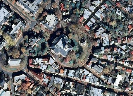
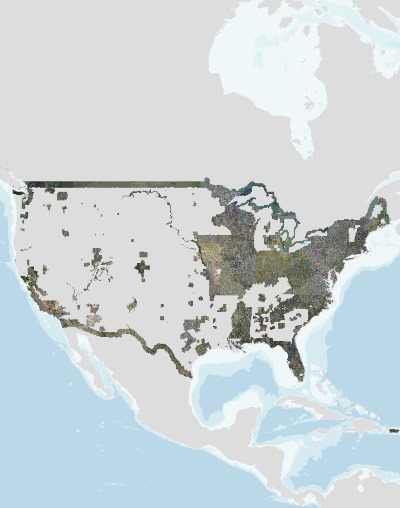
USGS_EROS_Ortho_SCALE service contains orthorectified digital aerial photographs and satellite imagery that are commonly referred to as orthoimagery. The imagery in this service is derived from high resolution images that combine the visual attributes of an aerial photograph with the spatial accuracy and geometric characteristics of a map. The resolution is primarily 1-meter, and the source imagery is acquired through partnerships with U.S. Department of Agriculture’s Farm Service Agency and other cooperating Federal, State, and local agencies. One meter resolution imagery means that each pixel in the orthoimage covers one meter on the earth’s surface. TNM_Large_Scale_Imagery service data is viewed at scales of...
The USGS_EROS_Ortho_SCALE service from The National Map (TNM) contains orthorectified digital aerial photographs and satellite imagery that are commonly referred to as orthoimagery. The imagery in this service is derived from high resolution images that combine the visual attributes of an aerial photograph with the spatial accuracy and geometric characteristics of a map. The resolution is primarily 1-meter, and the source imagery is acquired through partnerships with U.S. Department of Agriculture’s Farm Service Agency and other cooperating Federal, State, and local agencies through the National Agriculture Imagery Program (NAIP). One meter resolution imagery means that each pixel in the orthoimage covers one meter...
As one of the cornerstones of the U.S. Geological Survey's (USGS) National Geospatial Program, The National Map is a collaborative effort among the USGS and other Federal, State, and local partners to improve and deliver topographic information for the Nation. It has many uses ranging from recreation to scientific analysis to emergency response. The National Map is easily accessible for display on the Web, as products and services, and as downloadable data. The geographic information available from The National Map includes orthoimagery (aerial photographs), elevation, geographic names, hydrography, boundaries, transportation, structures, and land cover.
USGS developed The National Map (TNM) Gazetteer as the Federal and national standard (ANSI INCITS 446-2008) for geographic nomenclature based on the Geographic Names Information System (GNIS). The National Map Gazetteer contains information about physical and cultural geographic features, geographic areas, and locational entities that are generally recognizable and locatable by name (have achieved some landmark status) and are of interest to any level of government or to the public for any purpose that would lead to the representation of the feature in printed or electronic maps and/or geographic information systems. The dataset includes features of all types in the United States, its associated areas, and Antarctica,...
Categories: Data;
Types: ArcGIS REST Map Service,
Map Service,
OGC WFS Layer,
OGC WMS Layer;
Tags: BGN,
Cultural Resources,
GNIS,
Geographic Names,
NGP-TNM,
USGS high resolution orthorectified images from The National Map combine the image characteristics of an aerial photograph with the geometric qualities of a map. An orthoimage is a uniform-scale image where corrections have been made for feature displacement such as building tilt and for scale variations caused by terrain relief, sensor geometry, and camera tilt. A mathematical equation based on ground control points, sensor calibration information, and a digital elevation model is applied to each pixel to rectify the image to obtain the geometric qualities of a map. A digital orthoimage may be created from several photographs mosaicked to form the final image. The source imagery may be black-and-white, natural...
The USGS Elevation Contours service from The National Map (TNM) consists of contours generated for the conterminous United States from 1- and 1/3 arc-second elevation data. Small scale contours derived from 1 arc-second data are displayed at scales ranging from 1:577K to 1:72K in The National Map viewer. Contour intervals are 100 foot between 1:577K and 1:144K, and 50 foot at 1:72K. Large scale contours derived from 1/3 arc-second data are displayed at 1:50K (and larger). Large scale contour intervals are variable across the United States depending on complexity of topography. The National Map viewer allows free downloads of public domain contour data in either Esri File Geodatabase or Shapefile formats. The 3D...
Categories: Data;
Types: ArcGIS REST Map Service,
Citation,
Map Service;
Tags: Elevation,
Elevation,
NGP-TNM,
Overlay Map Service,
REST,
The USGS Shaded Relief Large service from The National Map (TNM) was created from the National Elevation Dataset (NED), a seamless dataset of best available raster elevation data for the conterminous United States, Alaska, Hawaii, and Territorial Islands of the US. Derived from the NED using a hill shade technique, this base map represents a continental view showing shaded relief from USGS NED layers at resolutions of 1/3-, 1-, and 2-arc-second (in Alaska only). This hillshade is actually five separate shaded relief datasets created from the original terrain data. Each shaded relief has different azimuths and altitude values as follows: 0 45, 135 60, 270 45, 315 45, 45 45. These five datasets are then combined into...
The USGS National Hydrography Dataset (NHD) service from The National Map (TNM) is a comprehensive set of digital spatial data that encodes information about naturally occurring and constructed bodies of surface water (lakes, ponds, and reservoirs), paths through which water flows (canals, ditches, streams, and rivers), and related entities such as point features (springs, wells, stream gages, and dams). The information encoded about these features includes classification and other characteristics, delineation, geographic name, position and related measures, a "reach code" through which other information can be related to the NHD, and the direction of water flow. The network of reach codes delineating water and...
Categories: Data;
Types: ArcGIS REST Map Service,
Map Service;
Tags: HU,
Hydrography,
NGP-TNM,
NHD,
Overlay Map Service,
The USGS Elevation Contours service from The National Map (TNM) consists of contours generated for the conterminous United States from 1- and 1/3 arc-second elevation data. Small scale contours derived from 1 arc-second data are displayed at scales ranging from 1:577K to 1:72K in The National Map viewer. Contour intervals are 100 foot between 1:577K and 1:144K, and 50 foot at 1:72K. Large scale contours derived from 1/3 arc-second data are displayed at 1:50K (and larger). Large scale contour intervals are variable across the United States depending on complexity of topography. The National Map viewer allows free downloads of public domain contour data in either Esri File Geodatabase or Shapefile formats. The 3D...
|

|
