Filters: Tags: mojave desert (X) > partyWithName: Conservation Biology Institute (X)
45 results (174ms)|
Filters
Date Range
Tag Schemes |

The California Department of Fish and Game (CDFG) Vegetation Classification and Mapping Program (VegCAMP) and contractor Aerial Information Systems (AIS) created a fine-scale vegetation map of a portion of the western Mojave Desert in California. The mapped area is bounded to the west and south by USDA Ecoregional Subsection 322Ag of the Mojave Desert (Miles and Goudey 1997). To the east, the portion mapped by AIS (approx. 4,202,000 acres) is bounded by the borders of a vegetation map produced in 2004 for the Mojave Desert Ecosystem Program (MDEP). VegCAMP mapped a portion of the area mapped previously for the MDEP (approx. 776,000 acres) using the finer-scale rules and classification that AIS used for the larger...
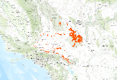
Mojave and Great Basin Upper Bajada and Toeslope distribution within the DRECP study area.This community was extracted from the Land/Use Natural Vegetation Communities dataset provided by Aerial Information Systems and the California Dept. of Fish and Game. Extractions were based on the GroupCommunity field.The California Department of Fish and Wildlife (CDFW) Vegetation Classification and Mapping Program (VegCAMP) and contractor Aerial Information Systems (AIS) created a fine-scale vegetation map of a portion of the western Mojave Desert in California. The mapped area is bounded to the west and south by USDA Ecoregional Subsection 322Ag of the Mojave Desert (Miles and Goudey 1997). To the east, the portion mapped...
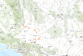
Intermontane Deep or Well-Drained Soil Scrub distribution within the DRECP study area.This community was extracted from the Land/Use Natural Vegetation Communities dataset provided by Aerial Information Systems and the California Dept. of Fish and Game. Extractions were based on the GroupCommunity field.The California Department of Fish and Wildlife (CDFW) Vegetation Classification and Mapping Program (VegCAMP) and contractor Aerial Information Systems (AIS) created a fine-scale vegetation map of a portion of the western Mojave Desert in California. The mapped area is bounded to the west and south by USDA Ecoregional Subsection 322Ag of the Mojave Desert (Miles and Goudey 1997). To the east, the portion mapped by...

The California Department of Fish and Game (CDFG) Vegetation Classification and Mapping Program (VegCAMP) and contractor Aerial Information Systems (AIS) created a fine-scale vegetation map of a portion of the western Mojave Desert in California. The mapped area is bounded to the west and south by USDA Ecoregional Subsection 322Ag of the Mojave Desert (Miles and Goudey 1997). To the east, the portion mapped by AIS (approx. 4,202,000 acres) is bounded by the borders of a vegetation map produced in 2004 for the Mojave Desert Ecosystem Program (MDEP). VegCAMP mapped a portion of the area mapped previously for the MDEP (approx. 776,000 acres) using the finer-scale rules and classification that AIS used for the larger...

The California Department of Fish and Game (CDFG) Vegetation Classification and Mapping Program (VegCAMP) and contractor Aerial Information Systems (AIS) created a fine-scale vegetation map of a portion of the western Mojave Desert in California. The mapped area is bounded to the west and south by USDA Ecoregional Subsection 322Ag of the Mojave Desert (Miles and Goudey 1997). To the east, the portion mapped by AIS (approx. 4,202,000 acres) is bounded by the borders of a vegetation map produced in 2004 for the Mojave Desert Ecosystem Program (MDEP). VegCAMP mapped a portion of the area mapped previously for the MDEP (approx. 776,000 acres) using the finer-scale rules and classification that AIS used for the larger...

Mojavean Semi-Desert Wash Scrub distribution within the DRECP study area.This community was extracted from the Land/Use Natural Vegetation Communities dataset provided by Aerial Information Systems and the California Dept. of Fish and Game. Extractions were based on the GroupCommunity field.The California Department of Fish and Wildlife (CDFW) Vegetation Classification and Mapping Program (VegCAMP) and contractor Aerial Information Systems (AIS) created a fine-scale vegetation map of a portion of the western Mojave Desert in California. The mapped area is bounded to the west and south by USDA Ecoregional Subsection 322Ag of the Mojave Desert (Miles and Goudey 1997). To the east, the portion mapped by AIS (approx....

California Annual Forb/Grass Vegetation distribution within the DRECP study area.This community was extracted from the Land/Use Natural Vegetation Communities dataset provided by Aerial Information Systems and the California Dept. of Fish and Game. Extractions were based on the GroupCommunity field.The California Department of Fish and Wildlife (CDFW) Vegetation Classification and Mapping Program (VegCAMP) and contractor Aerial Information Systems (AIS) created a fine-scale vegetation map of a portion of the western Mojave Desert in California. The mapped area is bounded to the west and south by USDA Ecoregional Subsection 322Ag of the Mojave Desert (Miles and Goudey 1997). To the east, the portion mapped by AIS...

Intermountain Mountain Big Sagebrush Shrubland and Steppe distribution within the DRECP study area.This community was extracted from the Land/Use Natural Vegetation Communities dataset provided by Aerial Information Systems and the California Dept. of Fish and Game. Extractions were based on the GroupCommunity field.The California Department of Fish and Wildlife (CDFW) Vegetation Classification and Mapping Program (VegCAMP) and contractor Aerial Information Systems (AIS) created a fine-scale vegetation map of a portion of the western Mojave Desert in California. The mapped area is bounded to the west and south by USDA Ecoregional Subsection 322Ag of the Mojave Desert (Miles and Goudey 1997). To the east, the portion...

30 meter resolution raster representation of the General Composition level values within the updated Land Cover/Natural Vegetation Communities vector dataset. The following description is from the vector version from which this dataset was derived: The California Department of Fish and Game (CDFG) Vegetation Classification and Mapping Program (VegCAMP) and contractor Aerial Information Systems (AIS) created a fine-scale vegetation map of a portion of the western Mojave Desert in California. The mapped area is bounded to the west and south by USDA Ecoregional Subsection 322Ag of the Mojave Desert (Miles and Goudey 1997). To the east, the portion mapped by AIS (approx. 4,202,000 acres) is bounded by the borders...

Californian Xeric Chaparral distribution within the DRECP study area.This community was extracted from the Land/Use Natural Vegetation Communities dataset provided by Aerial Information Systems and the California Dept. of Fish and Game. Extractions were based on the GroupCommunity field.The California Department of Fish and Wildlife (CDFW) Vegetation Classification and Mapping Program (VegCAMP) and contractor Aerial Information Systems (AIS) created a fine-scale vegetation map of a portion of the western Mojave Desert in California. The mapped area is bounded to the west and south by USDA Ecoregional Subsection 322Ag of the Mojave Desert (Miles and Goudey 1997). To the east, the portion mapped by AIS (approx. 4,202,000...

North American Warm Desert Bedrock Cliff and Outcrop distribution within the DRECP study area.This community was extracted from the Land/Use Natural Vegetation Communities dataset provided by Aerial Information Systems and the California Dept. of Fish and Game. Extractions were based on the GroupCommunity field.The California Department of Fish and Game (CDFG) Vegetation Classification and Mapping Program (VegCAMP) and contractor Aerial Information Systems (AIS) created a fine-scale vegetation map of a portion of the western Mojave Desert in California. The mapped area is bounded to the west and south by USDA Ecoregional Subsection 322Ag of the Mojave Desert (Miles and Goudey 1997). To the east, the portion mapped...

Southwestern North American Salt Basin and High Marsh distribution within the DRECP study area.This community was extracted from the Land/Use Natural Vegetation Communities dataset provided by Aerial Information Systems and the California Dept. of Fish and Game. Extractions were based on the GroupCommunity field.The California Department of Fish and Wildlife (CDFW) Vegetation Classification and Mapping Program (VegCAMP) and contractor Aerial Information Systems (AIS) created a fine-scale vegetation map of a portion of the western Mojave Desert in California. The mapped area is bounded to the west and south by USDA Ecoregional Subsection 322Ag of the Mojave Desert (Miles and Goudey 1997). To the east, the portion...

Central and South Coastal Californian Coastal Sage Scrub distribution within the DRECP study area.This community was extracted from the Land/Use Natural Vegetation Communities dataset provided by Aerial Information Systems and the California Dept. of Fish and Game. Extractions were based on the GroupCommunity field.The California Department of Fish and Wildlife (CDFW) Vegetation Classification and Mapping Program (VegCAMP) and contractor Aerial Information Systems (AIS) created a fine-scale vegetation map of a portion of the western Mojave Desert in California. The mapped area is bounded to the west and south by USDA Ecoregional Subsection 322Ag of the Mojave Desert (Miles and Goudey 1997). To the east, the portion...

Lower Bajada and Fan Mojavean - Sonoran Desert Scrub distribution within the DRECP study area.This community was extracted from the Land/Use Natural Vegetation Communities dataset provided by Aerial Information Systems and the California Dept. of Fish and Game. Extractions were based on the GroupCommunity field.The California Department of Fish and Wildlife (CDFW) Vegetation Classification and Mapping Program (VegCAMP) and contractor Aerial Information Systems (AIS) created a fine-scale vegetation map of a portion of the western Mojave Desert in California. The mapped area is bounded to the west and south by USDA Ecoregional Subsection 322Ag of the Mojave Desert (Miles and Goudey 1997). To the east, the portion...

Central and South Coastal California Seral Scrub distribution within the DRECP study area.This community was extracted from the Land/Use Natural Vegetation Communities dataset provided by Aerial Information Systems and the California Dept. of Fish and Game. Extractions were based on the GroupCommunity field.The California Department of Fish and Wildlife (CDFW) Vegetation Classification and Mapping Program (VegCAMP) and contractor Aerial Information Systems (AIS) created a fine-scale vegetation map of a portion of the western Mojave Desert in California. The mapped area is bounded to the west and south by USDA Ecoregional Subsection 322Ag of the Mojave Desert (Miles and Goudey 1997). To the east, the portion mapped...

The California Department of Fish and Game (CDFG) Vegetation Classification and Mapping Program (VegCAMP) and contractor Aerial Information Systems (AIS) created a fine-scale vegetation map of a portion of the western Mojave Desert in California. The mapped area is bounded to the west and south by USDA Ecoregional Subsection 322Ag of the Mojave Desert (Miles and Goudey 1997). To the east, the portion mapped by AIS (approx. 4,202,000 acres) is bounded by the borders of a vegetation map produced in 2004 for the Mojave Desert Ecosystem Program (MDEP). VegCAMP mapped a portion of the area mapped previously for the MDEP (approx. 776,000 acres) using the finer-scale rules and classification that AIS used for the larger...

Californian Mesic Chaparral distribution within the DRECP study area.This community was extracted from the Land/Use Natural Vegetation Communities dataset provided by Aerial Information Systems and the California Dept. of Fish and Game. Extractions were based on the GroupCommunity field.The California Department of Fish and Wildlife (CDFW) Vegetation Classification and Mapping Program (VegCAMP) and contractor Aerial Information Systems (AIS) created a fine-scale vegetation map of a portion of the western Mojave Desert in California. The mapped area is bounded to the west and south by USDA Ecoregional Subsection 322Ag of the Mojave Desert (Miles and Goudey 1997). To the east, the portion mapped by AIS (approx. 4,202,000...

Shadscale â Saltbush Cool Semi-desert Scrub distribution within the DRECP study area.This community was extracted from the Land/Use Natural Vegetation Communities dataset provided by Aerial Information Systems and the California Dept. of Fish and Game. Extractions were based on the GroupCommunity field.The California Department of Fish and Wildlife (CDFW) Vegetation Classification and Mapping Program (VegCAMP) and contractor Aerial Information Systems (AIS) created a fine-scale vegetation map of a portion of the western Mojave Desert in California. The mapped area is bounded to the west and south by USDA Ecoregional Subsection 322Ag of the Mojave Desert (Miles and Goudey 1997). To the east, the portion mapped...

Arizonan Upland Sonoran Desert Scrub distribution within the DRECP study area.This community was extracted from the Land/Use Natural Vegetation Communities dataset provided by Aerial Information Systems and the California Dept. of Fish and Game. Extractions were based on the GroupCommunity field.The California Department of Fish and Wildlife (CDFW) Vegetation Classification and Mapping Program (VegCAMP) and contractor Aerial Information Systems (AIS) created a fine-scale vegetation map of a portion of the western Mojave Desert in California. The mapped area is bounded to the west and south by USDA Ecoregional Subsection 322Ag of the Mojave Desert (Miles and Goudey 1997). To the east, the portion mapped by AIS (approx....

Southwestern North American Riparian Evergreen and Deciduous Woodland distribution within the DRECP study area.This community was extracted from the Land/Use Natural Vegetation Communities dataset provided by Aerial Information Systems and the California Dept. of Fish and Game. Extractions were based on the GroupCommunity field.The California Department of Fish and Wildlife (CDFW) Vegetation Classification and Mapping Program (VegCAMP) and contractor Aerial Information Systems (AIS) created a fine-scale vegetation map of a portion of the western Mojave Desert in California. The mapped area is bounded to the west and south by USDA Ecoregional Subsection 322Ag of the Mojave Desert (Miles and Goudey 1997). To the east,...
|

|
