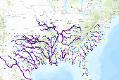
Ecologically relevant river size classes for NHDPlus v1 flowlines in the 14 state SARP region. Size class was determined for each river flowline using the cumulative drainage area from NHDPlus v1 dataset. The data are scaled to show the largest rivers at the regional scale. Zoom into the map for smaller rivers, creeks, and headwaters. For more information about how this attribute was developed by the Southern Instream Flow Network (SIFN), go to http://www.southeastaquatics.net/sarps-programs/sifn/instream-flow-resourcesYour comments about this dataset are welcome. Please send comments to the dataset author using the Comment tab below.Â
Summary
Ecologically relevant river size classes for NHDPlus v1 flowlines in the 14 state SARP region. Size class was determined for each river flowline using the cumulative drainage area from NHDPlus v1 dataset. The data are scaled to show the largest rivers at the regional scale. Zoom into the map for smaller rivers, creeks, and headwaters.Â
